Welcome to Life Images by Jill

Welcome to Life Images by Jill.........Stepping into the light and bringing together the images and stories of our world. I am a photographer, writer and multi-media artist.
Focussing mainly on Western Australia and Australia, I am seeking to preserve images and memories of the beautiful world in which we live and the people in it.

Welcome!

Welcome!
PLEASE CLICK ON THE IMAGE TO GO TO MY RED BUBBLE STORE.

Sunday 29 December 2013

Looking back over 2013 - and that's a wrap

 The last couple of days I have been sorting through the "flotsam and jetsam" of my life in boxes, cupboards, filing cabinets and shelves in my study. While looking through all these pieces I have been reliving events, cherishing memories, and discarding what I don't need to hang onto any longer. It has been a cleansing experience, and I haven't finished yet!

And so we arrive at the last few days of 2013 - and writing this blog post has been a good opportunity to look back over the year that has past and look forward with anticipation to the year ahead and its new opportunities, new horizons, new places to explore and the spark of new or renewed passions.


Whereas 2012 seemed to be focused around family - with a marriage, a funeral, elderly members moving into a new phase in their lives and the blessed welcome to a new addition to our family; in 2013 there were of course family events, joys and concerns, and life to get on with, but also new ventures and travel within our State, interstate and overseas. 


 Please click on "read more" to keeping reading and seeing more pics from 2013

Sunday 22 December 2013

Christmas baking while it's baking hot in Australia!

Hi everyone and welcome to my 2013 Christmas baking edition.  

While the far northern hemisphere enjoys a white Christmas we here in Australia swelter in the heat. But true to our European backgrounds we still bake the traditional goodies for Christmas - well some of us do anyway! 
I set last Monday aside for my Christmas baking. It really wasn't the weather for it (in the high 30sC), but Monday is my day off work, so it had to be done, heat or no heat. So I turned on the aircon and the overhead fan, put some cds in the player, and got to work. 


First off a new recipe for pear tarts which I saw in a Christmas magazine and wanted to try out. It is a fairly simple and easy recipe made with a base of bought puff pastry. While not technically for "Christmas cooking" we were going to our street "Christmas party" so I thought these would be something a bit different.

First you need pears - I used a pear variety which has a golden brown skin. 

Please click on "read more" to keep reading and see more Christmas baking!.... 


Sunday 15 December 2013

Christmas wishes to you from me in Australia

Christmas is just over a week away and I have finally put up my tree, reconstructed and hung my door wreath, sent my Christmas cards, and wrapped some presents. Tomorrow I have given over to Christmas cooking.  I will bring you photos when I'm done!

My sister makes the most amazing greeting cards - each one personally made for Christmas, birthdays, mother's day, father's day, etc.  They are works of art and I have kept every one and am going to put them all together in an album. 

Me? I take photos - so my greeting cards are often made from my images from our travels. 

 For Christmas I have had -
candles from Notre Dame Cathedral in Paris -


Please click on read more to keep reading...........

Monday 9 December 2013

South Australia trip - Part 6 - Outback Australia on the Oodnadatta Track


Welcome back for Part 6 of our trip through South Australia. If you missed the first five parts, please scroll down to the bottom of this post to go to the links.  Here is the link to the quick overview - On the road through South Australia.

Today we will continue north on the Stuart Highway to Marla where we turn south east on the Oodnadatta Track which will take us 638 kilometres along a dirt road to Marree. 


The Oodnadatta Track in South Australia can be described as hot, dry, dusty, bone shaking, and when we travelled recently, fly-ridden. However it is also one of Australia's great outback treks which has plenty to explore, fascinating and historical, and which is easily achievable over 3 or 4 days (4WD highly recommended). The track follows the Old Ghan railway line and along the way you can explore old railway bridges and stone ruins of the old railway sidings, learn it's history, and even see hot water bubbling up from the Artesian Basin and take a flight over spectacular Lake Eyre. You can bush camp, or stay at caravan parks at Coward Springs, Oodnadatta, and William Creek (make sure you have a drink in the pub and meet the locals - all 4 or 5 of them!). 

 But be prepared - this is remote outback travel - so please take all the necessary precautions including carrying drinking water, food, fuel and good quality tyres, 4WD highly recommended, and drive to the road conditions which can vary from good to badly corrugated, and watch out for potholes and washaways.

If you remember from Part 5 we travelled from the south up through Coober Pedy. Our final stop on the Stuart Highway was the Marla Roadhouse. A last chance to top up with fuel and supplies and make telephone calls (unfortunately no internet connection) before heading out along Oodnadatta Track. This little oasis, 160kms south of Northern Territory border, is a nice patch of green in the desert.

We had lunch under the shade of the trees at Marla before turning east onto the Oodnadatta Track. 


The history of the Oodnadatta Track goes back to the early1840s when central Australia was unexplored by Europeans and commonly thought to contain a massive inland sea.  But really its history goes back thousands of years before following a major Aboriginal trade route and steeped in Aboriginal history and dreamtime stories.  

We were finally here - on the Oodnadatta Track!  

Please click on "read more" to keeping reading and seeing more pics from the Oodnadatta Track. 


Tuesday 3 December 2013

Bilbarin morning

Life has been frantic the last couple of weeks, so this week I am trying to pace life a little better. I am sharing a little piece of creative writing with you that I wrote a few months ago for my writing group, South Side Quills.  

Bilbarin is a tiny wheatbelt siding town, where my mother spent her early years. All that remains is the town hall, but I am continually drawn to Bilbarin and the life and history of my mother and my grandmother. 

Perhaps today I am being drawn more to Bilbarin because my father will be there today when he visits the last resting place of my mother.   Or perhaps it is because it is nearly Christmas and this will be our second Christmas without my mother at our table.


Bilbarin Morning

A wild wind whips across the yard scattering leaves in devilish dance, battering a loose piece of tin on the roof and whistling through a crack in the sapling walls of the hut. 

Tendrils of golden morning light seep thinly through the trailing branches of the peppermint trees.  It bursts through the door as we tumble out onto the verandah in a blur of coats and scarves. Icy water baubles clinging in wait for us on the eaves release themselves as we bound down the steps. The ground crunches nosily under our boots like a military tattoo.  The gate clatters behind us. 


Daisy stamps impatiently in her stall. Her hot breath swirls around her like a smoky wreath. She thrusts her head into the stream of grain spilling into the feed bin.

Dry wheat stalks whip against our legs as we run across the stubble paddock.  Through the stringy gimlet trees, jumping the gurgling water in the gully, pushing our way through the scrub.  A kangaroo bounds away into the mist. 

Red gum flowers are bursting from their cups and we stop to pick a spray for Miss.

The clanging bell calls out to us across the dusty school yard. The welcoming warmth of the fire in the stove as we slide into our desks and pull out our books.   


Miss smiles at us, absorbing the perfume of the bush as she arranges the flowers in a jar on the window sill. 

                                                  ...................................................


and a couple of images from Bilbarin. A beautiful old gum tree near where my mother once lived, and the old railway siding.
You might enjoy this post from last year when I took you there for a visit - From beach to wheatbelt


Thanks for stopping by. I hope you enjoyed this little story. I look forward to hearing from you. Have a wonderful week.

I am linking up to Mosaic Monday, Travel Photos Monday, Our World Tuesday, Tuesday Around the World, Travel Photo Thursday, What's It Wednesday, and Oh the Places I've Been. Please click on the links to see fabulous contributions from around the world - virtual touring at its best!

Mosaic Monday
Travel Photo Mondays
Our World Tuesday
Wednesday Around the World  
What's It Wednesday
Travel Photo Thursday
 Oh The Places I've Been

Monday 25 November 2013

Photographing flowers and using clouds as a natural diffuser

I am taking a break today from blogging about our recent trip through South Australia. For those who are enjoying it, don't worry, I will be back.  Here is a link to the last post if you missed it - and you can scroll down to the complete list so far - South Australia Part 5 - Woomera, Coober Pedy & the Painted Desert

Yesterday I spent most of the day in my garden - my early summer flowers are starting to burst from their cups and it was a brilliant day for working in the garden as there was a light cloud cover, and in fact at one point it started to rain!


I have been so busy that it has been a while since I photographed flowers around my garden. I was grateful that the clouds were shading me as I worked and the overcast day got me thinking about how clouds act as a really great huge natural diffuser of the sun's light. This is perfect for photographing flowers as it balances, softens and evens out the light and you won't have blown out highlights, washed out colors, and harsh shadows. The diffused light will also help the colours of the flowers stand out. 


 So I took a break from my work for a while and got my camera out. 

Please click on "read more" to keep reading and see more pics! .........
 

Sunday 17 November 2013

South Austalia-Part 5 - Woomera, Coober Pedy & the Painted Desert

Welcome back for Part 4 of our trip through South Australia. If you missed the first three parts, please scroll down to the bottom of this post to go to the links.  Here is the link to the quick overview - On the road through South Australia.

Today we leave Port Augusta and the coast and travel up the Stuart Highway to Woomera, Coober Pedy, Arckaringa Station and the Painted Desert.  The blue line of this map shows an approximation of our route - 

The Stuart Highway runs for 3000 kilometres between Port Augusta up through central Australia to Darwin on the north coast. The Highway was named after explorer John McDouall Stuart who was the first European explorer to achieve the crossing in 1861-62, although the highway doesn't follow his exact route. His exploration to Darwin opened up the north and resulted in both the Overland Telegraph line and the Great Northern Railway. 

Travel along the Highway today is vastly different to what Stuart and his party would have experienced in 1861.  


 Please click on "Read more" to keep reading - there are lots more pics!


Monday 11 November 2013

Quandongs - delicious Australian bush food

Have you ever tasted Quandongs - or Quandong jam? Do you know what Quandongs are? Have you ever seen them in the bush?

Today I have taken a little side step from my blogging about our recent trip through South Australia - but really this post is a little more detail about a bush food you can see and taste in South Australia - the Quandong 


My curiosity with the Quandong started many years ago..... but even before this newspaper article in the West Australian newspaper in 1995 I knew about Quandongs. My mother said when she was a child they used to use quandong nuts on their Chinese Checkers game. 


 I wrote this creative piece for my writing group exercise -


The shiny red baubles hang in clusters glistening in the shafts of early morning light. It is a surprise to see them amongst the dull grey green. Their beauty entices me to crouch underneath their bright canopy. I reach up and gently tug at the nearest bauble. It resists and then yields. The ball is round and hard. I can see where it has been marked by creatures unseen. 
I squat on the carpet of green, red, yellow and brown balls that have fallen from the tree. Some are split and broken revealing a glimpse of the treasure within. I pick up one and pull aside the thin shell to reveal a perfectly round hard ball patterned with wavy lines. 
Curious I bite into the red ball that I have plucked from above. The tart bitter sweetness is a shock, but is irresistible. I nibble away the thin red and yellow layer and then secret the round knobbly nut in my pocket.  
As I reach up to pluck another bauble I sense someone is watching me. Looking across the clearing I see the soft brown eyes of a kangaroo gazing at me. In its hands is a bright red shiny bauble. 
- Jill Harrison, May 2013- 

  
I had seen plants during our travels through the Western Australia wheatbelt - but it was only a couple of years ago that I saw them fruiting and had the opportunity to taste them. They have a sharp bitter taste when eaten raw. 


Santalum Acuminatum or the Quandong 
CommonName: Quandong; Sweet Quandong, Wild Peach, Desert Peach, Native Peach, Guwandhuna, Gutchu, Wanjanu, Mangata, Goorti, Wadjal (Aboriginal names)
BotanicalName: Santalum acuminatum

distribution map The Quandong is a truly unique native Australian fruit. Traditionally the Quandong was an important food and medicinal source for Australian Aborigines and was also used by early pioneers and settlers as a fruit, or in jams and chutneys. Found in the arid and semi-arid regions of all Australian mainland states, Quandong trees are ideally adapted to arid environments. The Santalum Acuminatum species is known to be a semi-parasitic plant. Quandong trees can tolerate high soil salinity levels and often rely for their complete water requirements from the root systems of host plants. Across their native distribution range, Quandong trees typically grow 2 to 3 metres in height, with a dense leathery crown of leaves perhaps 2 metres wide. 

 You can read more about Quandongs at "Nullarbor Net" by clicking here - Quandongs - Nullarbornet

We have seen Quandong trees many times during our travels through the West Australian wheatbelt and along the Hyden to Norseman Road in Western Australia. More recently we saw them during our travels through South Australia.  They have a dull green dry looking leaf, but in season the bright red fruits attract your attention.
We saw this beautiful specimen you see here in the Coffin Bay area of the Eyre Peninsular in South Australia.

Quandongs are very similar to - Australian Sandalwood (Santalum spicatum) - and in fact belong to the same family.  Below you can see the Sandalwood on the left and the Quandong on the right.  The nut of the Sandalwood is smooth (sorry you can't see it in this picture) whilst the nut of the Quandong is nobbly. 


Harvesting wild Quandong fruit is prohibited, but when we visited the Australian Arid Lands Botanic Garden  in Port Augusta in South Australia in October, I purchased some Quandong fruit leather, preserves and dried Quandong, from plantation grown fruit by Bush Food Australia - click here - Bush Food Australia . We also tried the Quandong icecream and the Quandong cake in the Arid Lands cafe. The fruit has a tart-bitter sweet taste - delicious!


After our return home I made some Quandong jam - seen here below served with wattleseed pancakes and cream with wattleseed sprinkled over (watteseed is another bush food I bought from the Australian Arid Lands Botanic Garden)
Oh my goodness I am in raptures over quandong jam! 
I cooked down the fruit with a couple of green apples and the juice of 2 lemons. 
 

 You can buy dried Quandong from "Native Tastes of Australia" - click here to see more - Native Tastes of Australia
 On their site you will see some Quandong recipes including jam.  


 Here is an interesting post about edible native foods - click here - why-havent-we-embraced-indigenous-foods

 Thanks for stopping by. I hope you enjoyed learning something about the Quandong. Next week we will return to our South Australian travels.
If you missed any of my previous posts about our South Australia trip you can catch up by clicking on the links below -


 I am linking up to linkup sharing blogs below. Please click on the links to see fabulous contributions from around the world - virtual touring at its best!  Have a wonderful week.

Mosaic Monday
Travel Photo Mondays
Our World Tuesday
Tuesday Around the World  
Foodie Tuesday
What's It Wednesday
Travel Photo Thursday
 Oh The Places I've Been


Monday 4 November 2013

Rock formations and wildflowers in the Gawler Ranges National Park, South Australia

Welcome back to our trip from Western Australia and through South Australia. 
If you missed Part 2 last week, you can catch up by clicking here - Crossing Australia on the Eyre Highway
 

And so we leave Ceduna and continue along the Eyre Highway through the small towns of Poochera and Minnipa and across the top of the Eyre Peninsula. 

An approximation of our trail is shown here - 


17km north of Minnipa is the granite Pildappa Rock.  This is a lovely spot for a picnic or an overnight bush camp. A track goes around the rock and on one side of the rock you will see a wave formation - you an see it on the LHS of the collage below.  The walk over the rock is relatively easy and you will see various rock formations and fabulous views over surrounding farmland and the Gawler Ranges.  In a rock crevice near the picnic area is a garden reputed to have been planted by the Kwaterski sisters who lived nearby in 1938. It is thriving from run off from the rock. 
You can see it in the bottom middle pic here.....


I am trying out the "Read more" option....so please do click on the "read more" label to continue.... as there is lots more to read and lots more pics to enjoy!......

Monday 28 October 2013

Part 3 - South Australia trip - Crossing Australia - The Eyre Highway and the Nullabor

Welcome back. A couple of weeks ago I gave you a brief overview of our recent trip to South Australia. Last week I brought you the first part – the Hyden to Norseman Road in Western Australia. 
If you missed it, and the AMAZING wildflowers, please click here – Across the Woodlines - Hyden to Norseman, Western Australia


Today I bring you part 2 – Eyre Highway and the Nullarbor.  The journey from Norseman in Western Australia to Ceduna in South Australia (which is classed as being the 'Nullarbor' experience) is approximately 1,200 kilometres. Are you ready? - please fill up your water bottles, pack your tent, fasten your seat belts, and make sure you have your camera ready. 

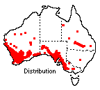
 Being far from bare as the word “Nullarbor” or this collage might imply, there is plenty to explore. Oh my goodness, there is a push-bike rider on the Eyre Highway!


As we drove across the Eyre Highway and the Nullarbor we thought about the first Europeans to cross here – it certainly wasn’t as easy as it is today.  

Aboriginal people, belonging to a number of different language groups, have lived in this vast area of southern Australia for over 35,000 years. There are signs of their heritage in 60 known archaeological sites. 

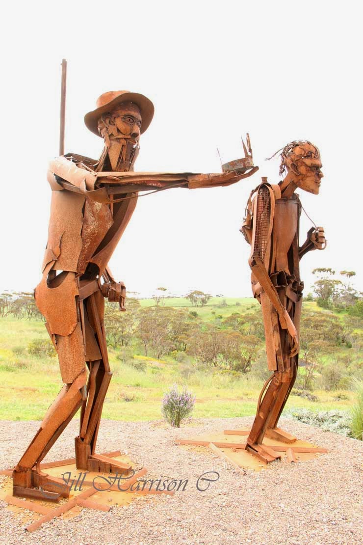
The crossing by Edward John Eyre and his aboriginal companion Wylie in 1840-41 is one of the most remarkable feats of endurance in Australian exploration history.  You can see various monuments throughout this part of Australia, including this sculpture dedicated to Eyre and Wylie at Kimba at the top of the Eyre Peninsular....

 It was another 30 years before anyone attempted the journey again.  An overland telegraph line between Perth and Adelaide (2,425 kilometres and 19,470 poles) was built in 1877 and the first track followed this line. In 1942 a graded road was constructed and the final bituminisation was completed in 1976.

Here is a map showing the Eyre Highway and this part of our trip - the dark blue thick line...


The lack of water was always a problem, and large corrugated iron roofs were erected along the highway to collect run off into tanks. You can still see some of these today - but don't rely on them for water! bring your own! 
 
The ruins of the Eucla Telegraph Station on the border of Western Australia and Adelaide is today being engulfed by shifting sand. Only the ruins of the station master’s residence remain. It is a fascinating place to visit. ……


It takes a few days to cross the Eyre Highway, especially if you are going to stop and look at the sights.  There are no towns, but road houses with motels and caravan parks will make the trip easier. There are also a number of free over night rest areas. You can find out about them by going to the Western Australian Main Roads site, click here -  Mainroads WA Rest Areas or by purchasing one of the Australian camping guide books. 

From the west coast it took us three and a half days and three nights bush camping to reach Streaky Bay in South Australia.
Below you can see them......Newman Rocks, Yalata (don't forget the flyspray and the insect repellent!), Moonera (our camp on our way back), and Jilah Rockhole. The bottom two pics show a typical roadside rest area, and our billy on the boil for that hot chocolate!


One of the best things about bush camping is the sunsets and sunrises that light up the sky….


Along the road there are trucks and other "big things" (a big kangaroo??). Take care when overtaking - the trucks I mean....  You will be amazed at what you might see….the bottom RH pic is of a burnt out truck that came to an unfortunate end in a truck bay. Hopefully the driver was unhurt. 


Signs to make sure you know where you are ….. like this one warning to be on the lookout for camels, wombats, and kangaroos. Wombats! We never saw any but you certainly wouldn’t want to run into one. The camels are feral herds which have been increasing to huge numbers since the days of the Afghan cameleers trains carting goods across outback Australia. Also be sure to don’t leave anything laying about your camp, particularly food, or you might find a dingo wanders in – and certainly don’t feed them. 


And even Royal Flying Doctor landing strips….yes, there are several of them along the highway - they actually use the highway as their airstrip.….well it is a straight piece of road!…..It is a quick way to assist people in medical trouble out here.


There is the longest stretch of straight road in Australia…… and the vastness of the southern Nullarbor Plain - and a sign to tell you when you get there….. 


 The Nullarbor Plain is the world’s largest limestone karst landscape covering an area of 270,000 square km, extending 2000 km between Norseman and Ceduna. Two thirds of the Nullarbor is within Western Australia and one third is in South Australia.The spectacular Bunda Cliffs and the Great Australian Bight border the area to the south and the northern border is the Great Victoria Desert.

In 1866 E. Alfred Delisser surveyed the Nullarbor Plain and noted a marked absence of trees. Contrary to some popular opinions the word Nullarbor is not of Aboriginal origins. In fact the local Mirning people referred to the area as "Oondiri" which is said to mean "the waterless". Delisser derived the term Nullarbor from the Latin "nulla" for no, and "arbor" for tree. Hence the term "Nullarbor" meaning “no trees”. 

However the plain is covered with bluebush and saltbush plants, hardy shrubs that are drought-resistant and salt-tolerant, with Myall acacia woodlands at the other edges. 


There are no towns between Norseman and Eucla, but there are Road Houses to fuel up your vehicle and you….however expect to pay high prices for fuel and food. You can also buy a shower.  Make sure your vehicle is reliable before crossing the Nullarbor as mechanical repairs will be expensive and time consuming - especially if parts have to be freighted in.


 There are cliffs and whales…….The Great Australian Bight Marine Park is a significant breeding and calving area at the Head of the Bight for the Southern Right Whale, and for sea lion colonies along the Bunda Cliffs. Whale watching at the Head of the Bight between June and October is a must for Nullarbor travellers. The access to the Head of the Bight lookout is 11km east of Nullarbor Roadhouse (please note you have to pay to go out on the Head of the Bight lookout).  Between Eucla and the Head of the Bight the Eyre Highway runs quite close to the cliff edge and there are various lookouts (don't climb over the railings). This is the Southern Ocean - next stop is Antarctica.


  At Border Village (on the border of WA & SA) you go through the Quaratine Station (if travelling east to west)……don’t carry any fresh fruit or vegetables (travelling west to east the quarantine station is at Ceduna). Please check the website and know what you can and can’t carry, it is easier that way….click on the link for an easy chart.... Australian domestic quarantine


There is even the Nullarbor Golf Links. This unique 18-hole par 72 golf course spans 1,365 kilometres from Kalgoorlie in Western Australia to Ceduna in South Australia. A single hole can be played in each participating town or roadhouse along the Eyre Highway, each featuring a green, a tee and a fairway of rugged outback natural terrain. ……make sure you allow more time for your trip if you intend playing all the holes, and collect your certificate when you sign up and complete the 18 holes. My son played the Links when he travelled across here a couple of years ago……click on the link to read more - Nullarbor Links
Oh and look out for giant "kangaroos" at the Border Village Link. LOL 


At Penong, on the western edge of the South Australian wheatbelt, you will see a cluster of community windmills in a paddock on the edge of the Eyre Highway. Known as "Windmill Flat" the 26 windmills are each privately owned supplying water for domestic and stock use. Being on the edge of the Nullarbor Plain it is not surprising that water is an issue for Penong. Wells were first sunk between 1868 and 1884 and windmill bores were later sunk to pump water from the Anjutabie Water Basin.  Penong still relies on rainfall as their main water source, with additional water carted by tankers from the Todd River pipeline, plus water pumped by the windmills. 


We thought is was an unusual sight so I took some pics - and just as well - as my story about Penong's windmills appeared in "Curious Australis" in the February 2014 edition of On The Road Magazine Australia.


At Fowlers Bay you can learn more about Matthew Flinders who named Fowlers Bay in 1802, and Edward John Eyre and his expedition which left here for the crossing of the Nullarbor on 25 February 1841. In the collage below you can see the jetty, a memorial to Flinders, a new hotel, the old telegraph station (now a private residence), and sandhills and salt lake at the edge of town. ….. I really like the way they have converted the old rail cart into a table and seats.


And at the end of it all you will reach Ceduna and the start of the next part of our journey. If you are travelling from west to east the Quarantine Station is here…..


I hope you have enjoyed Part 3 of our tour. I will be back next week when we go across the top of the Eyre Peninsula, through the Gawler Ranges where we see the amazing “Organ Pipes” rocks, and a stay in Port Augusta before turning north up the Stuart Highway and through outback South Australia. 

I am linking up to Mosaic Monday, Travel Photos Monday, Our World Tuesday, Tuesday Around the World, Travel Photo Thursday, What's It Wednesday, and Oh the Places I've Been. Please click on the links to see fabulous contributions from around the world - virtual touring at its best!


Mosaic Monday
Travel Photo Mondays
Our World Tuesday
Tuesday Around the World  
What's It Wednesday
Travel Photo Thursday
 Oh The Places I've Been


You might also like - 
On the road through South Australia
Across the woodlines - Hyden to Norseman, Western Australia
Dehydrating food for camping