Welcome to Life Images by Jill

Welcome to Life Images by Jill.........Stepping into the light and bringing together the images and stories of our world. I am a photographer, writer and multi-media artist.
Focussing mainly on Western Australia and Australia, I am seeking to preserve images and memories of the beautiful world in which we live and the people in it.

Welcome!

Welcome!
PLEASE CLICK ON THE IMAGE TO GO TO MY RED BUBBLE STORE.

Sunday 30 June 2013

Sunset over spinifex in World Heritage Purnululu, Western Australia

I was very excited to learn recently that I had won the "People's Choice" award for my image - "Purnululu Sunset" - at the  "60 shots @ 6" Photography Competition and Exhibition.


 The brief was to submit images taken half an hour either side of 6am or 6pm. We could submit five images - either "digitally enhanced" or "no enhancement". The 60 selected images were cropped to square and displayed in "cd cases" at the Front Room Artist Run Space at the Bunbury Regional Art Gallery. You can see more about it by clicking here - Front Room Artist Run Space

 The interesting thing about them being this small, is that instead of standing back as you might usually, you really had to stand up close to view the images.  My image was "no enhancement".


When we visited World Heritage listed - Purnululu - in the amazing Kimberley region of northern Western Australia, we went late one afternoon to one of the sunset viewing places - Kungkalahayi Lookout.  Here you can enjoy uninterrupted 360 degree panoramic views and watch the last rays of the sun spreading out over the Simpifex ridges and lighting up the ranges changing them to brilliant orange and reds. People often take a chair and enjoy sunset drinks here. There are also other parking bays along the roads through Purnululu where you can enjoy the sunsets. It is a lovely way to end the day.

It was here that I saw my image "Purnululu sunset". I loved the way the golden light of the late afternoon sun was lighting up the heads of the clumps of spinifex grass. 


I wrote in my diary - "At Kungkalahayi Lookout they have provided benches on which to sit, but we decided to walk over to an adjacent hill, and set up our chairs and camera. It was beautiful, the setting sun setting over the hill behind us, lighting up the Spinifex heads, and turning the rock faces to a brilliant red."

Little did I know then that my image would win a "People's Choice Award"! So exciting - my first photography competition and award and first time I have had a piece exhibited! I have now had my image printed onto canvas to display on my wall at home.

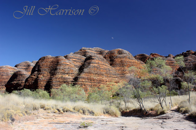
Given World Heritage listing in 2003, Purnululu (also known as the Bungle Bungles) is one of Western Australia’s newest and most spectacular National Parks.   


In the Kija Aboriginal language purnululu means sandstone. The Aboriginal people inhabited the region for thousands of years, however Purnululu was known only to a few Europeans until the mid 1980s.  How it received the name Bungle Bungles remains an intriguing mystery with several explanations including the name of a common Kimberley grass, bundle bundle grass, or the ranges proximity to the old Bungle Bungle cattle station. 

The ranges are the remains of a large sedimentary rock mass laid down about 360 million years ago, uplifted to form ranges, then moulded by erosion and weathering. An outer skin of silica and algae and a patina of iron and manganese oxidation gives the domes the rusty orange and dark grey bandings you see today. Contrary to its solid appearance the sandstone is very fragile. The weight of overlying rock holds the sand grains in place, but when this is removed the sandstone easily erodes demonstrated by the rounded tops of the Domes. 

Purnululu is rich in Aboriginal history and art, and there are many burial sites and places not accessible to tourists. The Aboriginal traditional owners make a valuable contribution to Purnululu through their joint management of the Park and are working with DEC to develop more walk trails for visitors. Visitors are reminded to never remove anything from Aboriginal historical sites.

 Below are some aerial shots I took when we enjoyed a flight from Kununurra. You can take helicopter rides at Purnululu or like we did, a fixed wing flight from Kununurra which included flying over Lake Argyle, the Argyle Diamond Mine, the Ord River plains and the surrounding station country.  It is an awesome experience to see the domes of Purnululu from the air rising dramatically 200-300 metres high out of the flat spinifex grass lands in a maze of domes, rocks, gorges and creek beds.


Purnululu is a perfect place to enjoy a wilderness experience, bush camping, walking, photography and nature observation and I recommend at least a two or three day visit to experience some of what Purnululu as to offer.  There are several walks, ranging from the easy one kilometre Domes walk to a 30 kilometre over night hike through Piccaninny Gorge (oh how I would love to do this one!). Each walk has its own particular characteristics and beauty and photographers should consider using a tripod to assist with the tricky lighting. The walk trails are generally exposed and along uneven rock surfaces and creek beds, so sturdy footwear, sunscreen, hat and carrying water is recommended.  Shaded picnic tables are located at the start of the walks.

My favourite gorge is Cathedral Gorge, and below is one of my favourite images - my husband and sun walking into Cathedral Gorge in the early morning light.They are my travel companions who support me and wait patiently while I take yet another photo! Without them I wouldn't have been able to travel over our beautiful country.


The moderate three kilometre return walk into Cathedral Gorge is one of the most spectacular walks in the Park.  It includes some short steep slopes and narrow ledges (allow one to two hours). The walk terminates within a circular towering amphitheatre, sheltering a central pool. An early morning walk is great for photography as you can capture the light filtering through the gorges and lighting up the rocks.


Cathedral Gorge is well named. Entering its immense towering cavern is like entering a magnificent natural cathedral, a place steeped in time and history. The red and orange sandstone walls tower above you, and the white sand crunches softly underfoot.  Tiny animal tracks can be seen going across the sand to the central pool which sits still and undisturbed like a mirror. It is a place for hushed voices and to sit quietly with your own thoughts. If you come early in the morning, as we did, you can enjoy the peace and atmosphere undisturbed before the crowds arive.  It has the atmosphere of a holy place, a sanctuary. We walked to Cathedral Gorge twice during our stay.


 I have tried to cobble some photos together to show you how immense it is - but this truly doesn't do it justice - 


 We visited Purnululu in July - the winter dry season. It was cold at night and hot during the day, so getting up early in the morning to go for the walks is the best idea. We had a lovely shady campsite, and spent the afternoons sitting around camp, reading, having a snooze (my husband), or looking at photos and writing notes (me), or doing Word Slueths (our son). Later in the afternoon we might go for another walk, or get ready for sunset drinks. 

Purnululu is an amazing place to visit. I recommend you put in on your must see places. I am looking forward to a return visit. 


Where is it?

Purnululu is located off the Great Northern Highway, 250km south of Kununurra, west of the WA/Northern Territory border. The 53 kilometre unsealed road from the Highway is only accessible by 4WD and offroad campers. It travels through Mabel Downs Station to the Department of Environment and Conservation (DEC) Rangers / Visitor Centre within the park. You should allow approximately 2-3 hours for the 53 km drive in (approximately 5 hours total travel time from Kununurra).


The Park is only open to visitors from April to December depending on weather conditions as during the summer “wet” season the unsealed road into the Park can become unpassable due to washaways and numerous creek crossings. We negotiated seven “wet” crossings during the “dry” season in July. Travellers must come entirely self sufficient with fuel, water, food and mechanical spares, although untreated water is available in the camping areas. On arrival visitors must register and pay their Park and camping fees at the Visitor Centre.  Here you can gather information about the Park, as well as purchasing souvenirs and cold drinks, so it is a good place to start your visit to Purnululu.

 For more information:

Department of Environment & Conservation, Kununurra. Phone 08 9168 4200
Purnululu Visitor Centre – April to December. Phone 08 9168 7300

DEC Nature Base – Nature Base
 Kimberley Australia Travel Guide: Kimberley Australia

Kununurra Visitor Centre Kununurra Tourism

Western Australian Tourism  - Australia's North West

Want to see more?

I hope you have enjoyed this little visit to this spectacular part of my State. Would you like to read more? 
Please see my blog posts - On the Road in the Kimberley
 and my articles in  November 2011 edition of On The Road Magazine. 


I am linking up to Mosaic Monday, Travel Photo Monday, Our World Tuesday, and Travel Photo Thursday. Please click on the links to see fabulous contributions from around the world - virtual touring at its best!
Mosaic Monday 
Travel Photo Mondays 
Our World Tuesday 
Travel Photo Thursday

Monday 24 June 2013

Camping with heritage - Karalee & Boondi Rocks - Western Australia


Over the last few weeks or so I have taken you up the Holland Track to Thursday Rock, Cave Rock, Burra Rock, Coolgardie and along the Perth to Kalgoorlie Pipeline. Today we continue our journey, turning westward along the Great Eastern Highway which connects  Perth and Kalgoorlie. 

If you missed my post about the pipeline, you can check it out by clicking here - The need for water on the goldfields

It can be a long drive from Perth to Kalgoorlie,  especially if you are exploring the Golden Pipeline Heritage Trail, but there are a couple of great picnic stops and campsites at granite rocks which I recommend you to stop and take a look at between Coolgardie and Yellowdine.  

The rocks are a great opportunity to take a break, explore and learn about the rocks, the goldfields, pipeline and railway and their importance to the development of the interior of Western Australia. 


Karalee, Boondi and Woolgangie Rocks feature rock catchments and dams built in the 1890s to service steam trains travelling between Perth and the Goldfields.


Thousands of years ago Aboriginal people camped at these rocks and collected water from the gnamma holes and soaks.  Early explorers, sandalwood cutters, travellers, prospectors, and supply teams also camped here, as well as construction workers building the railway line in the late 1800s and the Goldfields Water Supply Pipeline in 1902.  

Kilometres of granite slab walls up to a metre high, all cut from the rock and laid by hand surround the enormous rock catchments, directing the rainwater into the dams. It is amazing to see these constructions which were an enormous achievement of both manual labour and horsepower.   

In the mosaic below you can see the rock walls around the base of the rock, the channels through the bush, and the outlet into the dam at Karalee Rock.


 WOOLGANGIE
70 Kilometres west of Coolgardie is the remains of the former Woolgangie telegraph station. The rock catchment and dam was used by travellers on route to the goldfields before the railway line reached Woolgangie in December 1895. During the two months that Woolgangie was the railhead it became one of the busiest towns in Western Australia. During this time the region was gripped by severe drought. 1000 horses were stranded here quickly diminishing the water supply. A heavy thunderstorm on 9 January saved the dire situation. 

All that remains today at Woolgangie is one wall of the telegraph station, and the pipeline, but it is still an interesting stopover for a morning tea or lunch stop.  Sadly we didn't make time to climb up the rock (I wish we had). 


 BOONDI ROCK
7 kilometres west of Woolgangie is Boondi Rock, located in the Goldfields Woodlands National Park.  The day use and camping area, which is managed by WA Department of Environment & Conservation (DEC) is 3km north of the Highway. At Boondi Rock rainwater is directed off the rock into the Boondi dam by way of rock lined channels.  A walk trail takes you over the rock to the quarry and then back through the bush along one of the rock channels. You can see it in the picture below.


KARALEE ROCK
131 kilometres west of Coolgardie is Karalee, my favourite of the rocks along this section.

Karalee was officially gazetted as a water reserve in 1888 and by 1895 around 600 teams and 4,000 horses plying their trade between Southern Cross and Coolgardie regularly stopped here.

When the railway between Southern Cross and Kalgoorlie was completed in 1896 a series of rock walls, an aqueduct and 48.3 million litre dam was constructed at Karalee. Rain water is directed to flow off the rock into the dam via rock walls and a large semi-circular steel flume aqueduct, hand riveted at each joint. The flume has been conserved by the National Trust of Australia (WA) for its heritage value so we can still see it today.  The water was then pumped 3.6 kilometres south to the railway siding. 

Thanks to the National Trust and Southern Cross community, visitors can camp or picnic in the peaceful shady surrounds. Two marked walk trails with interpretive signage start not far from the camp ground and take you through bushland and over a section of rock. You can also walk around the dam wall.  When we camped here the sunset from the rock was magnificent. 

You can see the flume in the images below -


KARALEE & BOONDI CAMPSITES
The shady open campsites at Karalee and Boondi are lightly wooded with salmon gums, eucalypt and mallee trees.  Both are suitable for caravans, camper trailers and tents, although it can be sometimes difficult to hammer in pegs!  

We found that there were a lot of birds around the dam area, making it a great camping place for bird watchers. During spring the surrounding bushland would be ablaze with wildflowers. You may see red fruited quandong trees which were an important food source for Aboriginal people and early settlers. You can see the quandong fruit below.  Isn't that a wonderful sunrise?


One of the things I enjoy about bush camping is the sunsets. Away from the city lights they are amazing - how about this sunset at Karalee Rock......


I hope you have enjoyed the continuation of our tour.  Have you ever seen rock catchments like this in your part of the world? Do you have a favourite bush camping spot?
Have a great week. I look forward to hearing from you.


So how do you get there? -
Karalee Rock – GPS: -31.250561 119.84024 - 5km north of the Great Eastern Highway, 51km east of Southern Cross and 131km west of Coolgardie, on the northern side of the highway.
Boondi Rock – GPS: -31.181156  120.384468 - 3km north of the Great Eastern Highway, 108km east of Southern Cross and 77km west of Coolgardie.
Woolgangie –  GPS: -31.16235 120.55886 – approx 7km east of Boondi Rock on northern side of the Great Eastern Highway.
Facilities: Information boards, echo flushing toilet, hand washing basin, picnic tables and fire rings. Bring own firewood, be aware of fire restrictions and take away rubbish. The camping areas are suitable for caravans, camper trailers and tents. Non potable water.  There is a RV dump at Karalee. 
Wheelchair access: Wheelchair friendly toilet. 
Rates: Free
Pets : Not permitted at Boondi Rocks and not encouraged at Karalee due to wild dog baiting. 


Interested in learning more?  A couple of websites for you to check out - please click on the links -
DEC campgrounds Western Australia
Golden Pipeline Heritage Trail


I am linking up to Mosaic Monday (@Little Red House) Our World Tuesday, Travel Photo Thursday (@Budget Traveler's Sandbox) and a new linking party at Oh the Places I've Been (@The Tablescaper) Please click on the links to see contributions from around the world. 
 Mosaic Monday
Our World Tuesday 
Travel Photo Thursday 
Oh the Places I've Been 


Sunday 16 June 2013

Tamarillos - ‘tomate de arbol’ - Lost food of the Incas

 Do you know what these are?......
Have you tasted them?


Since I have started playing around with food photography, I have been trying fruits I have never tasted before in the search of something different to photograph.

Their origins read like an ancient history book.

and all these fruits are from other countries, so in a way tasting these fruits takes you to their origins. I love going to local markets when travelling, seeing the fresh produce and tasting new flavours. 

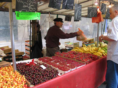
Here you can see the market in Bercy, Paris.  Wow, look at those cherries and raspberries!


I have tried -

Persimmons                   and       Cumquats  from China


Pomegranates from Iran to the Himalayas


and Quinces  from Turkey

                        
My latest sweet tangy tart taste sensation is Tamarillos - lost food of the Incas.


Tamarillos are a relative of the potato, tomato, eggplant and capsicum pepper. Also known as the tree tomato it is native to Central and South America.  Listed among the lost foods of the Incas and known as the ‘tomate de arbol’, tree tomatoes have all but disappeared from their native habitat.
Tamarillos were first introduced into New Zealand from Asia in the late 1800’s.  Originally only yellow and purple-fruited strains were produced.  The red tamarillo was developed in the 1920’s by an Auckland nurseryman from seed from South America.


Tamarillos rate very highly as a source of vitamins, minerals and antioxidants when compared with other common fruits and vegetables.

Tamarillos can be eaten raw (don't eat the skin), cooked, in savoury and sweet dishes, and in chutneys, jams and sauces.      

I found a very simple recipe - just halve, dolop on a bit of butter, spoon on some brown sugar, grill under the griller for a minute or so, and then serve with yoghurt. I added some Pomegranate seeds too.   Oh my goodness! Delicious! Delicious! 

I am going to have to try my friend's recommendation  -  "I peel and slice them, sprinkle them with a good bit of icing sugar and leave them to sit a few hours or overnight. You get this wonderful sweet and tangy flavours. Looks fantastic and tastes great with Pavlova."


  Have you tried Tamarillos?  Is there another interesting fruit or vegetable you have just discovered?
 If you haven't tried Tamarillos before you should! ps - don't eat the skin. 
I am going to put some away in the freezer to add into my tomato chutney next summer. 

I have just added three tamarillos to the tomato sauce in this Pumpkin & Recotta Cannelloni - they certainly added an extra tang. You peel them by first plunging them in boiling water for a few minutes - like you would do with tomatoes. They can then be peeled easily.
I wish I knew how to make cannelloni look less messy on the plate!


Want to find out more about Tamarillos? You will find lots of background info, recipes etc by  clicking onto the New Zealand Tamarillo Growers Association site here - Tamarillo

Thanks for stopping by. I look forward to hearing from you.
I am linking up with Mosaic Monday and Our World Tuesday and Travel Photo Thursday  Please click on the link to see contributions from around the world.   
Mosaic Monday at Little Red House
Our World Tuesday
Travel Photo Thursday 

You might also like - 


Persimmons and pasta 
The fruits of summer
Cumquats - from tree to marmalade