Welcome to Life Images by Jill

Welcome to Life Images by Jill.........Stepping into the light and bringing together the images and stories of our world. I am a photographer, writer and multi-media artist.
Focussing mainly on Western Australia and Australia, I am seeking to preserve images and memories of the beautiful world in which we live and the people in it.

Welcome!

Welcome!
PLEASE CLICK ON THE IMAGE TO GO TO MY RED BUBBLE STORE.
Showing posts with label Australian wildflowers. Show all posts

Sunday, 10 April 2016

How to make Lilly Pilly Jam - a delicious Australian bush tucker delight

When we moved to our current home about 20 years or so ago we found a Lilly Pilly bush in our front yard.  This is a plant native to the eastern states of Australia, but which grows well in the west too. It has very fleshy leaves and a very attractive small flower, which you can see below, but which withers almost immediately if picked.  The bees love them.


Following flowering a small red fruit forms, about the length of your thumbnail. We have tasted them from time to time over the years. They have a crisp flesh, not unpleasant taste, though slightly acid, and probably an acquired taste.  They have a small stone in the middle. You can see my bush and the fruit below here. 


The origin of the name Lilly Pilly is unknown. The first recorded sighting of a lilly pilly in Australia was Syzygium paniculatum. On May 3 1770 at Botany Bay botanist Joseph Banks stated in his journal: They "found also several trees which bore fruit of the Jambosa kind, much in colour and shape resembling cherries; of these they eat plentifully and brought home also abundance, which we eat with much pleasure tho they had little to recommend them but light acid."
From:  Australian Plants OnLine 

There are several varieties of Lilly Pilly, belonging to the  Myrtaceae family. 
The Lilly Pilly was a bush tucker for the Aboriginal inhabitants, and was prized by early European settlers for making jams and jellies.  It seems to have been used soon after the establishment of Sydney town in New South Wales. 

Jam making is a tradition in my family and I have been intending to make Lilly Pilly Jam ever since I discovered the plant in our front garden, and yesterday I did. My husband wanted to prune the bush as it had got quite big and was starting to develop a scale infestation as it had the previous year. So I picked about a kilo and a half of fruit and made the jam on Saturday morning. 


 The recipe I used came originally from the National Trust of Australia, New South Wales, and is in my Australia's Home Made Jams and Preserves Book compiled by sugar company CSR. I have used many recipes in this little book. 

The recipe was actually for jelly, but I adapted it to make jam. 

Lilly Pilly Jam 

Remove stalks and stones from the fruit and wash well. Place in the pan with a little water. I used 2 cups of water to 1.245kgs of fruit. Cook until fruit is tender (about an hour). I also added one lemon cut in half to the pan as the lemon will help with setting. 
When the fruit is tender add the same weight of sugar as the weight of fruit. 
Boil till jam sets when tested. This took about another hour, but will really depend on the quantity you are cooking. 
Remove the lemon halves, bottle the jam in sterile jars and seal immediately. 


The jam is a beautiful deep pink-red colour and I think tastes a little like a mix between plum and strawberry jam. Delicious! I made scones this morning so my family could taste the jam. They all enjoyed it, so I think I will from now on be making Lilly Pilly jam every year. 


Another reference to the Lilly Pilly can be found in May Gibb's children's book, The Complete Adventures of Snugglepot and Cuddlepie, an Australian classic about the gum nut babies first published in 1918. I told you about the bad Banksia Men from the book a couple of weeks ago. Please click here if you missed it -  Celebration of the Australian Banksia

Below is an illustration from the book of the characters Lilly Pilly and Ragged Blossom. In the book Lilly Pilly is an actress.  You can see here below on the left with the lilly pilly fruit forming the skirt of her dress. 
For more about May Gibbs click here - May Gibbs


I hope you have enjoyed my blog post about the Lilly Pilly. If you are in Australia and you have it growing in your garden, I hope you will make some Lilly Pilly Jam. 
Is there a native fruit that you make into jam? Perhaps you would like to share with us in the comments.

Here are a couple of references on the web:
Burke's Back Yard
Australian Native Plants Society
Evergreen Growers - scale pest on Lilly Pilly
Taste Australia - Bush Food
Nursery Near Me - Bush Tucker for the Garden


Thank you so much for stopping by. I value your comments and look forward to hearing from you. I will try to visit your blogs in return. Have a wonderful week.

I am linking up to the link-ups below. Please click on the links to see fabulous contributions from around the world - virtual touring at its best!

Mosaic Monday
Travel Photo Mondays

 Lifestyle Fifty Monday Linkup 
 Life Thru the Lens

Our World Tuesday
Through My Lens 
Image-in-ing
Wednesday Around the World at Communal Global
Worth Casing Wednesday
What's It Wednesday
Travel Photo Thursday

The Weekly Postcard

 You might also like - 
Quandongs, delicious Australian bush food
And slices of quince which they ate with a runcible spoon
Tamarillos, lost food of the Incas 


Tuesday, 29 March 2016

Celebration of the Australian Banksia

On Easter Saturday we celebrated my nephew's wedding in Perth. Despite the drizzling rain it was a beautiful day. The bride's bouquet was mostly Australian native wildflowers. The main flower you can see here is Banksia.  There is also some Australian eucalypti and South African protea.


Banksia is from the Proteaceae family. 

Spread across the southern hemisphere, it is most commonly found in Australia and the southern regions of Africa. Australian native Proteaceae include Hakeas, Banksias, Lambertias, Dryandra, Macadamias, and Grevilleas, and the Warratah, the state flower of the Australian state, New South Wales. (from the net:  proteaceae - flowers for everyone)

The Proteaceae family comprises about 80 genera with about 1,600 species. There are 173 Banksia species, and all but one occur naturally only in Australia. 
 South western Australia contains the greatest diversity of banksias, with 60 species recorded.  (from the web - Australian National Herbarium)

The presence of the Proteaceae family in Australia, South America and South Africa led scientists to put forward the idea that these land masses were once joined, forming a supercontinent which they named Gondwanaland. Australia has the greatest diversity of Proteaceae. They occur in the rainforests, the deserts, on coastal sand dunes and in alpine regions.  (from the net: ABC gardening)

 Here are two examples:  Ashby's Banksia and the Showy Dryandra. 


I love taking wildflower photos, but I am not a botanist, so I can't absolutely identify any of the banksias below, but I hope you enjoy the images. These have been mostly taken around the South West of Western Australia.


Sunday, 23 March 2014

South Australia trip - Part 8 - Exploring Wilpena Pound, Flinders Ranges National Park

Last week I continued our South Australian trip and blogged about our overnight camp in Brachina Gorge in the Flinders Ranges. If you missed it, you can click here – South Australia trip Part 7 - Brachina Gorge
 
Re-fuelled by that enormous burger in Hawker, and after replenishing our supplies, we climbed back into our 4WD and headed north again into the Flinders Ranges National Park to Wilpena Pound. 


Wilpena is very popular with people visiting the Flinders Ranges and as we arrived latish in the day we couldn’t get a powered site, but we were not really worried as we have solar panels that charge up our camper batteries.  We could select our own site, which were not so crammed together as the powered sites (another bonus) and chose one sheltered by some trees and overlooking a rehabilitation area. Nice. We could see kangaroos grazing amongst the trees only about 30 metres from our camper. We put up our full annex as we booked in for 3 nights – it gives us a bit more private space and the wind had come up strong during the afternoon. 
 

 We woke up next day to a fine clear morning, and put a load of washing into the washing machine before breakfast, and got organised to go for a bush walk. We had studied our guide the night before and worked out what we wanted to do while we were here.
 
There are 18 walk and hiking trails in the Flinders Ranges, some of which are easily accessed from the Wilpena Pound camp ground. Once the washing was on the line we drove to the Arkaroo Rock Hike about 17km south of Wilpena. Here there is a 3km return walk to see some Adnyamathanha aboriginal rock paintings under a rock overhang which are best seen in morning light. These ochre and charcoal drawings depict aspects of Ura Muda (dreaming) for Ikara (Wilpena). They have been enclosed in a wire enclosure to protect them from graffiti. Sad that this has had to be done, but at least they are now being protected and preserved. The Adnyamathanha people are the traditional custodians of the Flinders Ranges. 
Hubbie likes taking photos of lizards - you can see one in the collage below...


After lunch, we followed a 116km scenic loop drive through the Ranges which brought us to some lookouts with magnificent views and we checked out a few of the bush camping sites. 

 We also visited Aroona Hut built in 1925 from typical pine and pug construction. The Australian landscape artist, Sir Hans Heysen’s used to often come to paint. You can see his inspiration in the magnificent river gums and the Flinders Ranges.

Parts of the long distance Heysen walk trail meanders through the Flinders Ranges. 

On the way back from camp we saw lots of emus with chicks in the grasslands by the roadside.
Our second night was very cold and the wind was up so we put on our thermals and were in bed by 8.30pm. A bit different to the heat we’d had on the Oodnadatta Track! 


 Next morning we rose early and were on the 7.8km return Wangara Lookout Hike by 8am. This trail starts near the Wilpena camp ground. It was a lovely cool morning for walking. The first part is easy going and it was very pleasant walking on the flat trail beside the creek under the Red River Gums and I was delighted to be able to take some wildflower photos. 


The trail takes you to the old stone-built Hills Homestead built in the early 1900s by early settlers, the Hill's family. As well as the history of farming in the area you can learn about the creation of the Flinders through aboriginal dream-time stories.


From here there is a rocky path to the lookout. There is a lower lookout 300 metres from the homestead, and an upper lookout 300 metres further up. Both lookouts give you magnificent views over the Wilpena Pound, known as Ikara by the Adnyamathanha people.  The Pound itself is a huge natural amphitheatre 11km long and 5km wide. Surrounded by ranges, the highest point is St Mary Peak, 1170 metres high and the highest peak in South Australia. 
My photos certainly don't come close to portraying the grandeur of Wilpena Pound. 


A shuttle bus can take you the first 2km along the trail if you wish, but it is an easy walk. We decided that we didn’t need to do the more strenuous St Mary Peak walk to see the Pound and views of the Flinders Ranges. 22km and 9 hours, you would need a reasonable level of fitness to do this hike. 


After lunch we drove out to Stokes Hill lookout about 20km north east of Wilpena where you have magnificent 360 views over the rolling green hillsides at the base of the Flinders Ranges. We took quite a few photos in the changing light.  Surprisingly I thought it looked a little like an English countryside postcard.  Here there is a base relief sculpture which gives you a good perspective of the Ranges. 


Along the way we stopped at Cazneaux Tree. This magnificent River Red Gum was first made famous by photographer Harold Cazneaux, who won first prize at an International Photographic Exhibition in 1937 with his photograph of the tree, which he entitled “The Spirit of Endurance”. You can see my pic below! 


 On the way back we viewed the Artists of the Flinders Art Exhibition at the old Wipena Woolshed. (Sadly all the paintings I would have bought had already been purchased – not that I would have known how we were going to transport a painting for the rest of our trip!)

I hope you have enjoyed this brief look at Wilpena Pound. You could spend months exploring the Flinders Ranges. Unfortunately we only had time to scratch the surface.  However we really enjoyed our short stay and could have easily stayed longer to do more of the walks. From here we will head south to Burra via Hawker, Quorn, Cradock and Carrieton, and then to Clare wine region, and the next part of our trip through South Australia. 

 Some info: ………..

  • The Flinders Ranges National Park is one of South Australia’s iconic destinations. It covers 95,000 hectares of the central Flinders Ranges, approximately 450km north of Adelaide. 
  • Camp sites at Wilpena Pound are suitable for tents, camper trailers, motorhomes and caravans.  You can buy basic supplies, drinks, snacks, and souvenirs from the shop adjacent to the Visitor Information Centre.
  • You can enjoy a meal at the Wilpena Pound Resort restuarant.
  •  Walks and hikes range from 500 metres to 31km, including guided walks and challenging overnight treks. Please refer to brochures and information boards regarding distances, level of fitness required and degree of difficulty.
  • The long distant Heysen walking trail stretches 1200km from the tip of the Fleurieu Peninsular in the south to Parachilna Gorge in the Flinders Ranges. The 900km Mawson mountain bike trail runs from Adelaide through the Flinders to Blinman. 
  • Best time to visit: April to October 
  • Park pass and camping fees apply. 
  • Pets not permitted. 
  • Another caravan and camping park close by to Wipena is Rawnsley Park Station - www.rawnsleypark.com.au 
  •  
  • For more information about the Flinders Ranges please click here www.parks.sa.gov.au 
  • www.wilpenapound.com.au 
  • Flinders Ranges - An Adventurer’s Guide by Ron and Viv Moon is an excellent guide book - www.guidebooks.com.au 
This is one of our wattles - truly the most recognizable of all Australian flowers. 

 If you missed any of my previous posts about our South Australia trip you can catch up by clicking on the links below -

Thanks for stopping by. I value your comments and look forward to hearing from you. Have a wonderful week.
I am linking up to Mosaic Monday, Travel Photos Monday, Our World Tuesday, Wednesday Around the World, Travel Photo Thursday, What's It Wednesday, and Oh the Places I've Been. Please click on the links to see fabulous contributions from around the world - virtual touring at its best!

Mosaic Monday  
Travel Photo Mondays  
Our World Tuesday  
Wednesday Around the World  
What's It Wednesday    
Travel Photo Thursday
 Oh The Places I've Been


Monday, 4 November 2013

Rock formations and wildflowers in the Gawler Ranges National Park, South Australia

Welcome back to our trip from Western Australia and through South Australia. 
If you missed Part 2 last week, you can catch up by clicking here - Crossing Australia on the Eyre Highway
 

And so we leave Ceduna and continue along the Eyre Highway through the small towns of Poochera and Minnipa and across the top of the Eyre Peninsula. 

An approximation of our trail is shown here - 


17km north of Minnipa is the granite Pildappa Rock.  This is a lovely spot for a picnic or an overnight bush camp. A track goes around the rock and on one side of the rock you will see a wave formation - you an see it on the LHS of the collage below.  The walk over the rock is relatively easy and you will see various rock formations and fabulous views over surrounding farmland and the Gawler Ranges.  In a rock crevice near the picnic area is a garden reputed to have been planted by the Kwaterski sisters who lived nearby in 1938. It is thriving from run off from the rock. 
You can see it in the bottom middle pic here.....


I am trying out the "Read more" option....so please do click on the "read more" label to continue.... as there is lots more to read and lots more pics to enjoy!......

Monday, 28 October 2013

Part 3 - South Australia trip - Crossing Australia - The Eyre Highway and the Nullabor

Welcome back. A couple of weeks ago I gave you a brief overview of our recent trip to South Australia. Last week I brought you the first part – the Hyden to Norseman Road in Western Australia. 
If you missed it, and the AMAZING wildflowers, please click here – Across the Woodlines - Hyden to Norseman, Western Australia


Today I bring you part 2 – Eyre Highway and the Nullarbor.  The journey from Norseman in Western Australia to Ceduna in South Australia (which is classed as being the 'Nullarbor' experience) is approximately 1,200 kilometres. Are you ready? - please fill up your water bottles, pack your tent, fasten your seat belts, and make sure you have your camera ready. 

 Being far from bare as the word “Nullarbor” or this collage might imply, there is plenty to explore. Oh my goodness, there is a push-bike rider on the Eyre Highway!


As we drove across the Eyre Highway and the Nullarbor we thought about the first Europeans to cross here – it certainly wasn’t as easy as it is today.  

Aboriginal people, belonging to a number of different language groups, have lived in this vast area of southern Australia for over 35,000 years. There are signs of their heritage in 60 known archaeological sites. 

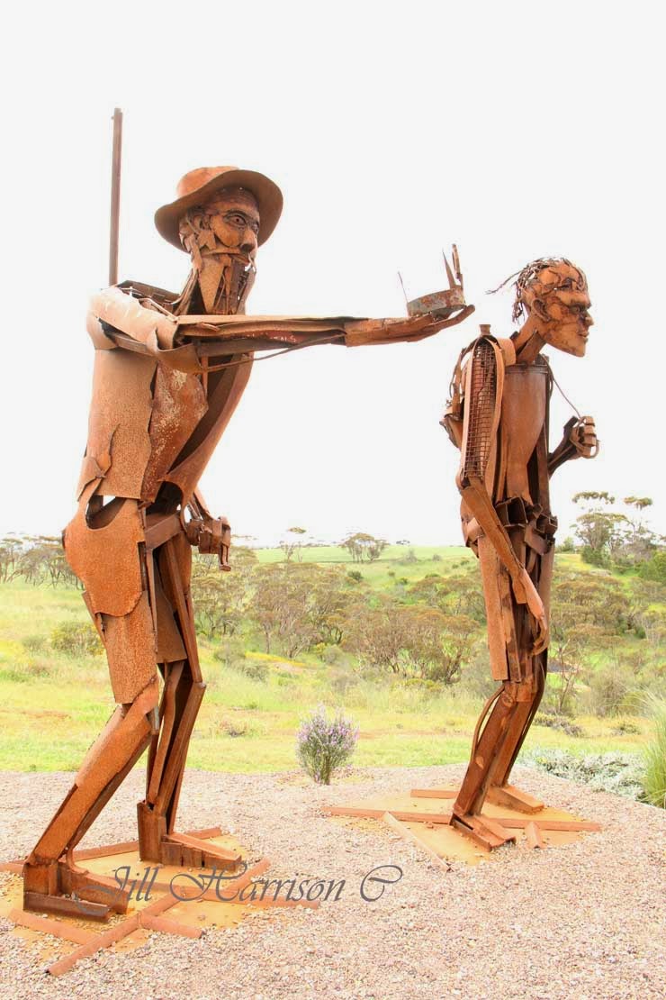
The crossing by Edward John Eyre and his aboriginal companion Wylie in 1840-41 is one of the most remarkable feats of endurance in Australian exploration history.  You can see various monuments throughout this part of Australia, including this sculpture dedicated to Eyre and Wylie at Kimba at the top of the Eyre Peninsular....

 It was another 30 years before anyone attempted the journey again.  An overland telegraph line between Perth and Adelaide (2,425 kilometres and 19,470 poles) was built in 1877 and the first track followed this line. In 1942 a graded road was constructed and the final bituminisation was completed in 1976.

Here is a map showing the Eyre Highway and this part of our trip - the dark blue thick line...


The lack of water was always a problem, and large corrugated iron roofs were erected along the highway to collect run off into tanks. You can still see some of these today - but don't rely on them for water! bring your own! 
 
The ruins of the Eucla Telegraph Station on the border of Western Australia and Adelaide is today being engulfed by shifting sand. Only the ruins of the station master’s residence remain. It is a fascinating place to visit. ……


It takes a few days to cross the Eyre Highway, especially if you are going to stop and look at the sights.  There are no towns, but road houses with motels and caravan parks will make the trip easier. There are also a number of free over night rest areas. You can find out about them by going to the Western Australian Main Roads site, click here -  Mainroads WA Rest Areas or by purchasing one of the Australian camping guide books. 

From the west coast it took us three and a half days and three nights bush camping to reach Streaky Bay in South Australia.
Below you can see them......Newman Rocks, Yalata (don't forget the flyspray and the insect repellent!), Moonera (our camp on our way back), and Jilah Rockhole. The bottom two pics show a typical roadside rest area, and our billy on the boil for that hot chocolate!


One of the best things about bush camping is the sunsets and sunrises that light up the sky….


Along the road there are trucks and other "big things" (a big kangaroo??). Take care when overtaking - the trucks I mean....  You will be amazed at what you might see….the bottom RH pic is of a burnt out truck that came to an unfortunate end in a truck bay. Hopefully the driver was unhurt. 


Signs to make sure you know where you are ….. like this one warning to be on the lookout for camels, wombats, and kangaroos. Wombats! We never saw any but you certainly wouldn’t want to run into one. The camels are feral herds which have been increasing to huge numbers since the days of the Afghan cameleers trains carting goods across outback Australia. Also be sure to don’t leave anything laying about your camp, particularly food, or you might find a dingo wanders in – and certainly don’t feed them. 


And even Royal Flying Doctor landing strips….yes, there are several of them along the highway - they actually use the highway as their airstrip.….well it is a straight piece of road!…..It is a quick way to assist people in medical trouble out here.


There is the longest stretch of straight road in Australia…… and the vastness of the southern Nullarbor Plain - and a sign to tell you when you get there….. 


 The Nullarbor Plain is the world’s largest limestone karst landscape covering an area of 270,000 square km, extending 2000 km between Norseman and Ceduna. Two thirds of the Nullarbor is within Western Australia and one third is in South Australia.The spectacular Bunda Cliffs and the Great Australian Bight border the area to the south and the northern border is the Great Victoria Desert.

In 1866 E. Alfred Delisser surveyed the Nullarbor Plain and noted a marked absence of trees. Contrary to some popular opinions the word Nullarbor is not of Aboriginal origins. In fact the local Mirning people referred to the area as "Oondiri" which is said to mean "the waterless". Delisser derived the term Nullarbor from the Latin "nulla" for no, and "arbor" for tree. Hence the term "Nullarbor" meaning “no trees”. 

However the plain is covered with bluebush and saltbush plants, hardy shrubs that are drought-resistant and salt-tolerant, with Myall acacia woodlands at the other edges. 


There are no towns between Norseman and Eucla, but there are Road Houses to fuel up your vehicle and you….however expect to pay high prices for fuel and food. You can also buy a shower.  Make sure your vehicle is reliable before crossing the Nullarbor as mechanical repairs will be expensive and time consuming - especially if parts have to be freighted in.


 There are cliffs and whales…….The Great Australian Bight Marine Park is a significant breeding and calving area at the Head of the Bight for the Southern Right Whale, and for sea lion colonies along the Bunda Cliffs. Whale watching at the Head of the Bight between June and October is a must for Nullarbor travellers. The access to the Head of the Bight lookout is 11km east of Nullarbor Roadhouse (please note you have to pay to go out on the Head of the Bight lookout).  Between Eucla and the Head of the Bight the Eyre Highway runs quite close to the cliff edge and there are various lookouts (don't climb over the railings). This is the Southern Ocean - next stop is Antarctica.


  At Border Village (on the border of WA & SA) you go through the Quaratine Station (if travelling east to west)……don’t carry any fresh fruit or vegetables (travelling west to east the quarantine station is at Ceduna). Please check the website and know what you can and can’t carry, it is easier that way….click on the link for an easy chart.... Australian domestic quarantine


There is even the Nullarbor Golf Links. This unique 18-hole par 72 golf course spans 1,365 kilometres from Kalgoorlie in Western Australia to Ceduna in South Australia. A single hole can be played in each participating town or roadhouse along the Eyre Highway, each featuring a green, a tee and a fairway of rugged outback natural terrain. ……make sure you allow more time for your trip if you intend playing all the holes, and collect your certificate when you sign up and complete the 18 holes. My son played the Links when he travelled across here a couple of years ago……click on the link to read more - Nullarbor Links
Oh and look out for giant "kangaroos" at the Border Village Link. LOL 


At Penong, on the western edge of the South Australian wheatbelt, you will see a cluster of community windmills in a paddock on the edge of the Eyre Highway. Known as "Windmill Flat" the 26 windmills are each privately owned supplying water for domestic and stock use. Being on the edge of the Nullarbor Plain it is not surprising that water is an issue for Penong. Wells were first sunk between 1868 and 1884 and windmill bores were later sunk to pump water from the Anjutabie Water Basin.  Penong still relies on rainfall as their main water source, with additional water carted by tankers from the Todd River pipeline, plus water pumped by the windmills. 


We thought is was an unusual sight so I took some pics - and just as well - as my story about Penong's windmills appeared in "Curious Australis" in the February 2014 edition of On The Road Magazine Australia.


At Fowlers Bay you can learn more about Matthew Flinders who named Fowlers Bay in 1802, and Edward John Eyre and his expedition which left here for the crossing of the Nullarbor on 25 February 1841. In the collage below you can see the jetty, a memorial to Flinders, a new hotel, the old telegraph station (now a private residence), and sandhills and salt lake at the edge of town. ….. I really like the way they have converted the old rail cart into a table and seats.


And at the end of it all you will reach Ceduna and the start of the next part of our journey. If you are travelling from west to east the Quarantine Station is here…..


I hope you have enjoyed Part 3 of our tour. I will be back next week when we go across the top of the Eyre Peninsula, through the Gawler Ranges where we see the amazing “Organ Pipes” rocks, and a stay in Port Augusta before turning north up the Stuart Highway and through outback South Australia. 

I am linking up to Mosaic Monday, Travel Photos Monday, Our World Tuesday, Tuesday Around the World, Travel Photo Thursday, What's It Wednesday, and Oh the Places I've Been. Please click on the links to see fabulous contributions from around the world - virtual touring at its best!


Mosaic Monday
Travel Photo Mondays
Our World Tuesday
Tuesday Around the World  
What's It Wednesday
Travel Photo Thursday
 Oh The Places I've Been


You might also like - 
On the road through South Australia
Across the woodlines - Hyden to Norseman, Western Australia
Dehydrating food for camping