Welcome to Life Images by Jill

Welcome to Life Images by Jill.........Stepping into the light and bringing together the images and stories of our world. I am a photographer, writer and multi-media artist.
Focussing mainly on Western Australia and Australia, I am seeking to preserve images and memories of the beautiful world in which we live and the people in it.

Welcome!

Welcome!
PLEASE CLICK ON THE IMAGE TO GO TO MY RED BUBBLE STORE.

Sunday, 28 July 2024

Four Aces and One Tree Bridge, Nannup, Western Australia

Hi all, I hope you are doing well. A couple of weeks ago I took you down to Nannup in Western Australia's south west where we explored some of the walk trails over a weekend. If you missed it you can see it here - Weekend away and bushwalking in Nannup, Western Australia

As promised, this week I am taking you to the Four Aces and the One Tree Bridge located 37 kilometres east of Nannup via Vasse Highway and then Graphite Road towards Manjimup. We decided to park at the Four Aces picnic area about one kilometre short of the bridge. From here you can follow a 400 metre loop walk through the karri trees before walking the one kilometre (each way) to One Tree Bridge. 

But first the drive through the karris. Karris are my favourite tree of the southern forests. 

Western Australia’s southern forests are dominated by Karri (Eucalyptus diversicolor) trees which grow only in WA’s wettest corner.  Belonging to one of the 900 Australian eucalypt species, many of the Karri trees are over 400 years old. Reaching a maximum height of about 90 metres they are one of the tallest forest trees in the world - behind the Californian Sequoia Redwood and the Australian Mountain Ash. Karri’s are easily identified. Their long straight trunk has a smooth bark which is shed every year, and changes colour as it matures. Interspersed with the Karri are Tingles, Jarrah, Marri, Bullich and Blackbutt trees and a stunning display of over 1500 wildflower species from September to November. 

The Four Aces are 4 tall karris growing evenly spaced in a straight line - you can see them in the photo above. Estimated to be over 250 years old, and over 70 metres tall, it is thought these trees grew up in a fallen log from seedlings in the ash of a previously fallen karri tree which had possibly been burnt in a bushfire. 

 From here there is a 400 metre Karri Glade loop walk trail through the karri forest, suitable for all levels of fitness. It was a pleasant walk through the forest. Take your time to appreciate the forest. 

Unfortunately we were too early for wildflower season, but there is always something to photograph. 
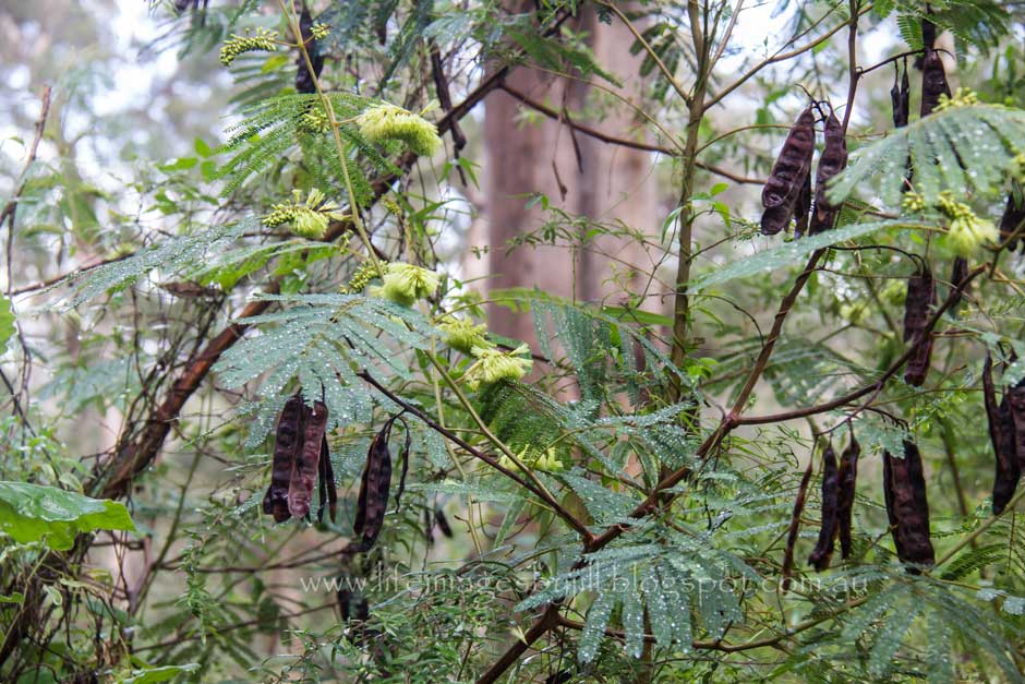
The yellow flower below is I believe the Cape Leeuwin Wattle (Paraserianthes lophantha). It has a fern type leaf and is common in karri forest, though I don't think I have seen it in flower before. There are invasive wattles from the Eastern states in the south west forests, so I was glad to learn this is not one of them.

Below that is bracken fern, a fungi, and a fallen leaf. 


We then walked the one kilometre through the karri forest to One Tree Bridge


At One Tree Bridge you can see the remains of a bridge built from a single karri log over the Donnelly River. In 1904 there was no bridge over the river, so settlers Herbert and Walter Gilblett felled the giant karri across the 250 metre wide river, forming the basis of the bridge. Jarrah tree wood was used to complete the building of the bridge. Only part of this bridge survives today. 

In 1948 a second bridge was constructed. In 1955 a new bridge was constructed to cater for heavy log trucks. This is the bridge that operates today, with a foot bridge adjacent. You can see the remains of the old bridge below here and the new bridge and footbridge below that. 


The early days of One Tree Bridge (Manjimup Historical Society)

The 1,000 kilometre Bibbulmum Track from Perth to Albany and the Munda Biddi bike trail crosses the river here at One Tree Bridge south of Donnelly River township. 


Munda Biddi markers on left, Bibbulmun Track on right. 

From One Tree Bridge we returned to Four Aces and had our lunch under the picnic and information shelter while the rain drizzled. It is a beautiful spot to just sit and absorb the forest sights and sounds. 


Below clockwise from top left - Water Bush (Bossiaea acquifolium) - it's amazing the amount of rain water it drops on you when you brush past, Karri Hazel (Trymalium floribundum), Tassel Flower (Leucopogon verticillatus) and a native orchid leaf emerging. Sadly none in flower!


And a Spotted Pardalote pair we saw at Four Aces - female on the left, male on the right. Thanks to my husband for these photos. It was lovely sitting at the picnic area listening to all the birds.


You cannot camp at either Four Aces or One Tree Bridge but there is a campground at Green Island, about 4.6 kilometres away -  turn back towards Nannup on Graphite Road and then turn north at the Green Island sign. Gravel road but suitable for 2-wheel-drive. 
There are 21 campsites surrounding a central grassy cleared area suitable for tents, camper trailers and small caravans. Jack and Irene Green first settled here in 1929 with the hopes of growing tobacco. Unfortunately the venture failed and they left after several years of hard work. 


On our way back to Nannup we stopped in at Tank 7 Mountain Bike Park - two kilometres east of Nannup on Brockman Highway. Here there are many mountain bike trails for all levels of experience. I am not a bike rider, let alone a mountain bike rider, so I don't have more photos to share. The bike trails are colour coded easy, moderate, difficult and extreme. I suggest you select the correct one for you! There is a good guide here - Tank 7 Mountain Bike Park


Thank you so much for stopping by. I value your comments and look forward to hearing from you. I will try to visit your blogs in return. Have a wonderful week. 
I am linking up to the link-ups below. Please click on the links to see fabulous contributions from around the world - virtual touring at its best!
   

Monday, 15 July 2024

Weekend away and bushwalking in Nannup, Western Australia

 Hi everyone, I hope you and yours are doing well. 

A couple of weekends ago, my husband and I went for a little weekend get-away down in Nannup, in Western Australia's south west. Only about 98 kilometres from where we live (about and hour and 20 minutes), it is a great place to get away without having to drive for hours. 

We stayed at a little fully contained cottage on a small acreage at Blackwood Banks Chalets - nestled between the Blackwood river and the state forest, about 20 kilometres south west of Nannup via the Brockman Highway. Just lovely. 


Arriving on Friday afternoon and leaving Monday morning, we could have stayed at the cottage all weekend relaxing, and there were a few places we could wander through the bush nearby, but we drove into Nannup for two bush walks on Saturday and then a little further afield on Sunday. 

Unfortunately being mid winter we were a little early for wildflowers. We parked in Nannup (just past the caravan park on Brockman Street) and walked across the old rail walk bridge, which is the start of the Timberline Trail, then branched off to walk through the Kondil Park where there are three walks - The 700 metre Casuarina Walk, the 2.5 kilometre Sheoak Walk and the 3.3 km Wildflower Wander. These are all circular walks which suit us. Trail signage helps you keep on track.  

There is also a parking area for the Kondil walk trails not far from Nannup off Barrabup Road. 

Below you can see the bridge over the river at the start of the trail in Nannup. If you walk down to the river on the right of this picture there is a tree with flood heights for different years marked. Amazing how high the river can reach in flood. 

And here we are on the Kondil walk trail. Markers help guide you - the axe is the Timberline Trail - and the footprint is the Kondil walk. 


Below are a few early wildflowers. I am not a botanist, so not absolutely correct with my identifications. From top left clockwise - one of the Greenhood orchids, one of the Hoveas, not sure of this white one, the orange is possibly Prickly Bitterpea, one of the Wattles, one of the Eucalypts possibly Karri tree, Wild Plum, last season's Hooded Lily, and in the centre fruit of the Snotty Gobble tree (Persoonia longifolia). Don't you just love that name! I love seeing this tree in the bush. 

From Kondil we walked back to the car at Nannup and then drove out to Barrabup Pool on the Timberline Trail within the St John Brook Conservation Park. We had our lunch under the shelters overlooking the pool.


First settled by Europeans in 1857, Nannup’s history revolves around the timber industry and the opening of the railway line in 1909.  

The Timberline Trail is a moderately easy 20 kilometre walk and cycle trail between Nannup and Cambray Siding, following part of an extensive network of disused forestry railway lines which once transported timber hauled by wood fired steam driven locomotives from bush camps to Barrabup, Nannup and Jarrahwood timber mills and then to Busselton Jetty on the coast for export during the early 20th Century.  

The Trail, which can be broken into sections, making it ideal for day or overnight walks, is marked by white triangular signs displaying an axe.  Interpretive signage along the way gives walkers a historical insight into the timber industry and the life of the timber cutters.  

You can see the trail on the map below. If you had a push-bike you could ride out on the Timberline Trail from Nannup to Cambray Siding, and then return to Nannup via the Sidings Rail Trail. As I don't have a bike I unfortunately haven't done the whole circuit. 
Distance:  Nannup to Cambray Siding via the Timberline Trail - 20 kilometres one way. Cambray Siding to Nannup via the Sidings Rail Trail - 15.24 kilometres one way


Hundreds of wooden sleepers were cut by hand with broad axes and laid by crews working in all weathers and living in canvas tents or simple wooden shelters in the bush. 
The majority of the railway sleepers have been removed but a few can still be seen along the Trail.  


After lunch we took the short walk out to the potato patch which was where vegetables were grown for the timber workers. 


The Timberline Trail is an easy shady walk. We have done it several times from Barrabup Pool to 
Sleeper Hewers Hut (5 kilometres and return), and then on another day from the opposite way from Cambray Siding to Sleeper Hewers Hut. (4.8 kilometres and return). I have talked more in depth about these walks in a previous post - The Old Timberline Trail, St Johns Brook, Nannup

A great App to have on your phone is the Experience Nannup app. This app shows you the trails around Nannup and the GPS tracker shows you exactly where you are. Last time we were in Nannup on the Timberline Trail we came across a guy on his bike who was lost. We were able to show him on the app where he was and guide him back to Nannup. 

As it is winter we didn't see many wildflowers along the trail, but there is always something to take a photo of. 

Clockwise from top left - Banksia nut, Tassel Flower (but not in flower), red inside the bark of the Snotty Gobble tree, Hovea, a caught leaf, and an emerging orchid (possibly one of the Greenhood orchid family). 


And a few birds which I managed to get photos of while we were having lunch. They don't stay still for long! 
From left to right - Red Winged Fairy Wren female, Red Winged Fairy Wren male, and a White Breasted Robin. 


It was now mid afternoon and we drove back to our cottage and enjoyed taking a walk and sitting on the front verandah watching the little birds. 

Below clockwise from top left - Spotted Scrub Wren, Splendid Fairy Wren - Dull plumage, Red Eared Firetail, Western Rosella male, Western Rosella male, Western Rosella Female. 

Why do they always turn their backs? 


And kangaroos! These are Western Grey Kangaroos. They had come up from the bushland and were sitting in the paddock near our cottage. 


And some photos from around Blackwood Banks Chalets


Nannup is 267 kilometres from Perth, Western Australia

For those interested in mountain biking, there are extensive trails around Nannup. Trailforks.com/Nannup

For more information on Nannup & the Timberline Trail

Timberline Trail, St Johns Brook - on my blog

Nannup Wildflower Walks - on my blog 

TrailsWA-Old Timberline trail

Trail Hiking- Old Timberline Trail

Experience Nannup

Experience Nannup app. - maps and GPS locator

On Sunday we went to 4 Aces and the One Tree Bridge out Graphite Road towards Manjimup, but that is a story for another time. 

Thank you so much for stopping by. I value your comments and look forward to hearing from you. I will try to visit your blogs in return. Have a wonderful week. 
I am linking up to the link-ups below. Please click on the links to see fabulous contributions from around the world - virtual touring at its best!


Sunday, 30 June 2024

Beringbooding Rock Water Tank, eastern wheatbelt, Western Australia

Built by sustenance labour, the largest rock water catchment tank in Australia gives us a glimpse into the past.

Hello everyone. I hope you and yours are doing well. Today I am taking  you away from the coast and up to the north-eastern wheatbelt, to Beringbooding Rock, one of the many granite outcrops found throughout the Western Australian wheatbelt.

Walls hewn from the rock surround the rock channelling the water

Beringbooding is dominated by a ten and a quarter million litre water tank built during 1937-38 for the farming community. It is the largest rock water catchment tank in Australia.  The concrete tank and catchment was built by sustenance labour. This scheme provided employment during the Great Depression. About 100 men were employed at Beringbooding at a cost of 10,000 pounds. One weeks work was given to each man for each child – for example four children equalled four weeks work. Those doing sustenance work had an extra 20 shillings per week added to their Government paid sustenance payment, which was seven shillings a day for up to five children with a maximum of 49 shillings a week.  They were brought by rail to nearby Bonnie Rock from Perth and lived in tents. These men were often unaccustomed to hard manual labour.

You can only marvel at the engineering and manpower that constructed this water catchment, and wonder about the first impressions of these city men when they were deposited in this far corner of the wheatbelt, beyond which lies uninhabited scrubland.

The tank is fed by a seven hectare catchment area. Rock walls hewn from the rock itself encircle the rock and channel the rain water via a concrete aqueduct into the tank. Big fires were lit on the granite and allowed to burn all night making the rock red hot. Water was then poured over the rock and the granite exploded in big layers. These slabs were sledged away, stood on their sides and cemented together to form the rock walls up to a metre high.

Over the years the corrugated iron roof covering the concrete tank started to come adrift through age and strong winds, creating a safety hazard, and has now been removed. However without a covering, water has been evaporating, and due to the significant amount of algae in the tank, the water has been deemed unfit for crop spraying, watering stock, or firefighting. Latest reports indicate the Shire of Mukinbudin has received funding to install a temporary cover and is committed to secure funding for a new permanent tin roof.

Camping area at Beringbooding Rock

The picnic and free camping area is conveniently located at the base of the rock. A 2.3 kilometre walk trail starts at the gate at the base of the tank and takes you over the rock to a variety of natural features

Rock cairn at the highest point, erected by HS King

I suggest you take a photo of the information map and allow a minimum of one and a half hours. The rock cairn at the highest point was erected in 1889 by surveyor and early explorer HS King.  You can enjoy spectacular 360 degree views over grain-growing farmland to the south and west, and virgin bushland to the north and east.

Gnamma hole surrounded by rock wall. The tank can be seen in the background.

Features include a huge balancing boulder that seems to defy gravity, a sheer rock face where the forces of nature have been at work, and gnamma holes: rock depressions which collect water during rain, providing an important water source for early Aboriginal people, settlers and animals. On the north eastern side of the rock you will find the “Kangaroo Hole”, a deep water natural pool. During October and November you will see the red Kunzia pulchella flowering next to the pool. It is amazing how plants can grow in small crevices in the rock.

Balancing rocks

Kangaroo Pool with flowering Kunzia in the foreground

The surrounding bushland includes salmon gums, sandalwood, melaleuca, acacia, grevillea, Ti-tree, hakea, cassia, kunzia, quandongs, and native orchids. Many birds inhabit the area.

Exploring the rock gardens

Clockwise from top left - Kunzia, wild orchids, quandongs, and Waitzia 

Throughout the wheatbelt you can see other similar rock catchment walls and dams. They make great places to stop and explore. You will also find evidence of other sustenance scheme projects throughout Western Australia.

FACTS BOX

Location :  Located 357km from Perth, near the intersection of Beringbooding and Cunderin Roads, about 65 kilometres north east of Mukinbudin and 13 kilometres east of the Bonnie Rock wheat bin in the Western Australian north-eastern wheatbelt. You might get a bit of an idea from this map below. The red dot is Beringbooding Rock, with our capital city Perth on the coast. 

Facilities:

There are several partly shaded compacted gravel hard standing sites suitable for caravans and camper trailers. Facilities include picnic tables, fire pits and an eco flushing toilet.  Non-potable water is available from a 60,000 litre water tank fed with piped water. Please bring your own firewood, and beware of fire restrictions and take away your rubbish.

The 2.3 km walk trail is suitable for those with a moderate level of fitness. Please take the usual bushwalking precautions. The rock can be slippery when wet.

Useful Information: 

Wheatbelt Tourism - https://www.wheatbelttourism.com/granite-outcrops-in-the-wheatbelt/

The Wheatbelt Way - https://wheatbeltway.com.au/

Shire of Mukinbudin - https://www.mukinbudin.wa.gov.au/

Ornate Dragon Lizard

Thank you so much for stopping by. I hope you have enjoyed learning a little of our history. My article about Beringbooding Rock was published recently in Caravan World magazine, June 2024 edition. 

I value your comments and look forward to hearing from you. I will try to visit your blogs in return. Have a wonderful week.

I am linking up to the link-ups below. Please click on the links to see fabulous contributions from around the world - virtual touring at its best!