There are many walks in the Cape to Capes region. Notably the Cape to Cape track
which one of these days I would love to do. It runs approximately 125 kilometres from Cape Naturaliste Lighthouse to Cape Leeuwin Lighthouse. But there are also many other walks which you can enjoy in the region. I've blogged about Cape Leeuwin last year - Cape Leeuwin - meeting of the Oceans
 |
| Cape Leeuwin Lighthouse - where the Indian & Southern Oceans meet |
 |
| Cape to Cape track |
You can pick up brochures and books at the Visitor Centres. We have had this book for many years, Walking The Capes by Jane Scott and beautiful illustrations by Patricia Negus, but there is now an updated version, Walking Round in Circles. The best thing of course about walking in circles, is that you can park your car at one point, and come back to it at the end of the walk without having to backtrack. The book outlines shorter and longer versions of walks, so you can choose how far you want to go depending on your fitness and how much time you have. The illustrations help you identify some of the plants, birds and other species you might see.
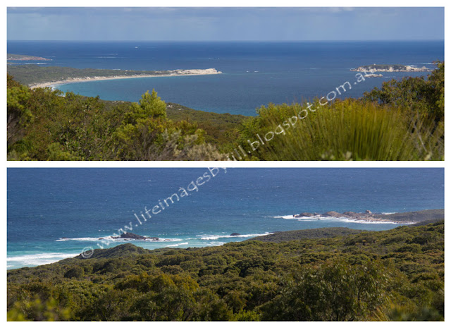
We decided to do the Boranup Lookout 9 kilometre loop (see map above), which starts at the Boranup Lookout, 3km from the southern end of Boranup Drive. From here you can see beautiful views over the coast. No camping allowed, but there is a picnic table. You can extend this to the 12 km walk.
Make sure you follow the usual hiking tips, wear a hat, carry water and food, wear good hiking boots, and as we found out on this loop walk, make sure you carry a map or guide as sometimes trails are not marked. More on that later.
The first part of the walk is gentle gradients through mixed forest, peppermint, karris, jarrah. The track alternates between sand and gravel. Early on in the walk we disturbed two kangaroos which hopped across the track in front of us, unfortunately I didn't ready my camera in time to get a photo.
It would be lovely in spring with the wildflowers. But there were a few. Below you can see the red Cockies Tongue - Templetonia retusa.
Here you can see the Easter Bunny Orchid - Eriochilus dilatatus subsp magnus - and in the bottom left hand corner is Parrot Bush - Dryandra sessilis
It was at this point on Arumvale Road where we saw Easter Bunny Orchid, that we misread our map and took a wrong turn to the right onto a side track. It was probably about a kilometre on that we realised our mistake. We did not feel that we were walking towards the beach, but parallel to it! So we had to backtrack back to where we had made our mistake. Looking at our GPS tracker later, I am very glad we realised before we had gone much further.
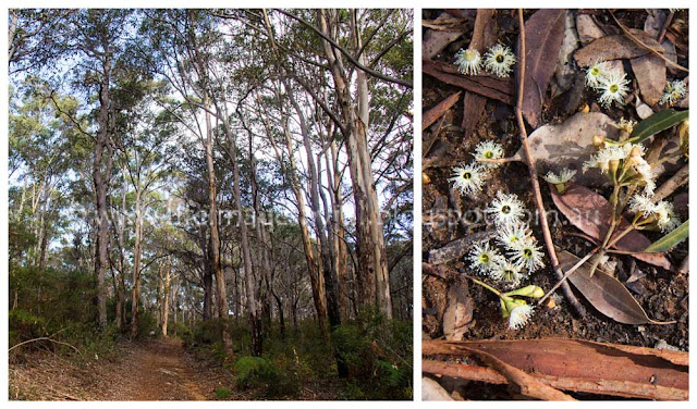
The photo below was taken in the tall Karri forest, about where we decided we had made a wrong turn. The flowers are karri flowers on the forest floor.
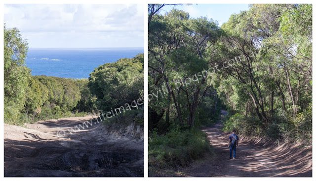
Back to the corner again, we continued on, and yes this time we were heading towards the beach as the track turned from gravel to sand on the coastal dunes.
If we had read our map correctly we would have noticed that the junction where we intended to turn south along Trig Road was an intersection with the Cape to Cape Track which was clearly marked. This is new Cape to Cape signage.
From here the sandy track, Trigg Road, ran south parallel with the coast. This was a bit of a hard slog up and down sandhills, with very little shade, but great views.
To give you some idea of it's size I asked my husband to pose with this huge Grass Tree - Xanthorrhoea. In the South West, the Aboriginal Noongar name is ' balga'.
A little bit further along the track he spied this Tiger Snake sunning itself by the edge of the track. It is one of Australia's most venomous snakes so we were very lucky he saw it before we stepped on it. A timely reminder that we were in the Australian bush, the habitat of snakes! They don't rear up and attack unless threatened, preferring to retreat, and I think this one was enjoying a sunshine siesta, but I am sure he knew we were there long before we saw him. I took a photo from a distance, then we walked on by along the other side of the track.
After two and a half kilometres of up and down sandhills, we came to the intersection with Grace Road 4 wheel drive sand track which leads down to the beach from Boranup Drive.
Then back to the Boranup lookout where we enjoyed our picnic lunch.
After lunch we decided to drive back along the gravel Boranup Drive through the amazing karri forest - truly one of my favourite trees. We stopped several times to take photos. The birds were having a high time highup in the canopy where the karris were flowering. It sounded like we were in a giant avairy. Just beautiful. Our car in this image below can give you some idea of the size the these trees.
I wanted to show you a little video, but Blogger is telling my my video was too long but you can view it on my Facebook page - Boranup forest video on Facebook
(I hope you will go and have a look- sorry about the dodgy phone video.... :)
Karri trees typically grows to a height of 10 to 60 metres (33 to 197 ft) but can reach as high as 90 m (295 ft) making it the tallest tree in Western Australia and one of the tallest trees in the world.
Thank you so much for stopping by. I hope you have enjoyed this look at bushwalking in the Boranup Forest. I value your comments and look forward to hearing from you. I will try to visit your blogs in return. Have a wonderful week.

I am linking up to the link-ups below. Please click on the links to see fabulous contributions from around the world - virtual touring at its best!
The Lovin' Life Team over at: Deep Fried Fruit
Little Things Thursday
Friday Bliss at Floral Passions
Little Things Thursday
Friday Bliss at Floral Passions
Hello there! I love reading your comments. If you scroll down to the bottom you can comment too! I would love to hear from you.


