Welcome to Life Images by Jill

Welcome to Life Images by Jill.........Stepping into the light and bringing together the images and stories of our world. I am a photographer, writer and multi-media artist.
Focussing mainly on Western Australia and Australia, I am seeking to preserve images and memories of the beautiful world in which we live and the people in it.

Welcome!

Welcome!
PLEASE CLICK ON THE IMAGE TO GO TO MY RED BUBBLE STORE.
Showing posts with label lighthouse. Show all posts

Monday, 23 January 2023

400 year anniversary of the European mapping of Cape Leeuwin, Western Australia

 Hi everyone, I hope you and yours are doing well.

A little bit of Western Australian history today.... the first European mapping of Cape Leeuwin on Western Australia's south west corner. You can see my previous post here -  Cape-leeuwin-meeting-of-oceans-western-australia

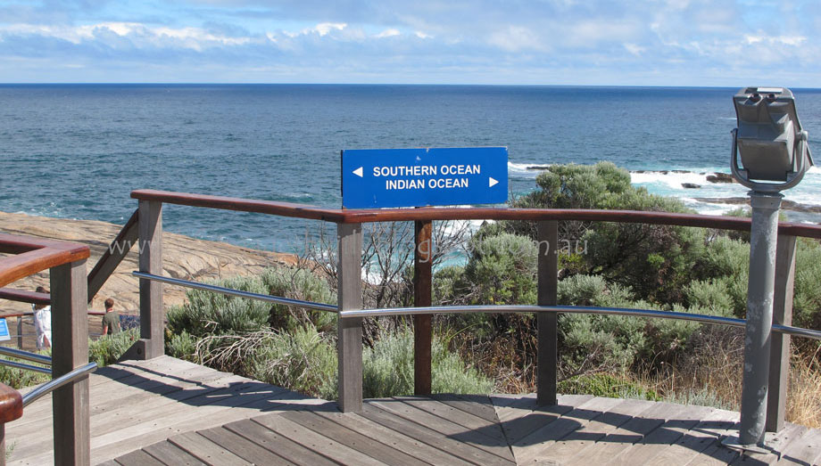
Nine kilometres south of Augusta, the Cape is located on the extreme south-west point of Western Australia, where the Indian and Southern Oceans meet.

A community day in Augusta and the Cape Leeuwin lighthouse was held on Sunday 30 October 2022 to commemorate the 400 year anniversary of the mapping of Cape Leeuwin by Europeans. 

The first inhabitants, the Wardandi indigenous people, called it Doogalup.

Accidental landfalls on the Great South Land by Dutch trading vessels on their way to the East Indies started to occur along the coast around 1616, when they adopted new sailing directions east from the Cape of Good Hope. 

Taking advantage of the Roaring Forties trade winds, sailing time was halved. Ships sailed south from the Cape of Good Hope (S36º-S44º), and then 3865 nautical miles east before turning north. However, inaccuracies in measurement resulted in many ships making contact with the Western Australian coast. 

The Dutch navigators called the Cape, Leeuwin’s Land (Land van de Leeuwin), after the ship Leeuwin (The Lioness) which sighted the Cape in March 1622. Unfortunately the Leeuwin’s log books have been lost, so very little is known of the voyage, although letters revealed the Leeuwin was the first vessel to sail the continent’s most southerly latitudes.  


above is - Hessel Gerritsz, Map of the Land of the Eendracht (1627). Wikimedia Commons / Public Domain

This part of the coastline first appeared on charts (Chart of the Land of Eendracht) in 1627 by Dutch cartographer, Hessel Gerritsz showing the coast between present-day Hamelin Bay and Point D’Entrecasteaux. (see the map above)

Subsequent maps showed other, sometimes accidental, discoveries along the coast between 1616 and 1628 – including Dirk Hartog’s discoveries in 1616.

In 1644 the western and northern coast of Australia was named New Holland by Dutch seafarer Abel Tasman, known for his discovery of Tasmania (Van Diemen's Land) off the southern tip of eastern Australia.

English navigator Matthew Flinders acknowledged the Dutch name, Leeuwin’s Land, when he named Cape Leeuwin, on December 7, 1801 during his circumnavigation and mapping of Australia in the HMS Investigator between 1801 and 1803. Flinders landed in the bay to the east of Cape Leeuwin, today's Flinders Bay.

Aboriginal man Bungaree sailed with Flinders, using his knowledge of Aboriginal protocol to negotiate peaceful meetings with local Indigenous people.

Located on the tip of the Cape, the Cape Leeuwin Lighthouse is the tallest lighthouse on mainland Australia and an important link in the chain of essential navigation aids around the Australian coast.


The official opening of the lighthouse was made by the Premier of Western Australia, Sir John Forrest, on December 10, 1896.


Although the Cape Leeuwin lighthouse was officially proposed in 1881, there were several delays including the need to excavate more than 1,000 cubic metres of earth when loose boulders instead of bedrock was encountered on the site.  Constructed from local tamala limestone quarried about 1.2 kilometres away at Quarry Bay, the tower is built on a 6.7 metre foundation, with 2 metre thick walls at the base and an elevation of 56 metres above Mean Tide Level. The light was automated in August 1992 and has a range of approximately 25 nautical miles.


Shallow rocks stretching 7 kilometres out from the Cape, diverging currents and massive swells claimed 22 ships before the lighthouse was built. Winds can reach 100-160 kilometres on the Cape. 

..... dramatic on a stormy day! 


Visitors can climb to the viewing area via 176 steps, but the fascinating tour and the expansive 360 degree views are worth the climb. It is a great place to spot Humpback and Southern Right whales May to September as well as fur seals and sea birds. The first image in this post, and the view of the cottages from above are from the top of the lighthouse. 


The October 2022 celebration was forced to move to the Augusta Centennial Hall by bad weather, but featured many activities including a Welcome to Country by Iszaac Webb, unveiling of a commemorative plaque by the Ambassador of the Kingdom of the Netherlands, Marion Derckx, and rollicking sea shanties by the Anchormen.

The Interpretive Centre and tours at the heritage listed lighthouse and keepers cottages precinct reveal its history and the lives of the numerous lighthouse keepers. The lighthouse has been undergoing a once in a century renovation and has now reopened. Check the website for opening hours – usually 9am to 4pm. Refreshments available at the Cafe.

You can also visit the nearby waterwheel (which you can see in the collage above), built in 1895 to supply water during construction of the lighthouse, and later to supply water to the lighthouse keepers’ cottages. Today the wheel is encrusted with calcified lime but it is a reminder of the past.

The Cape to Cape track traverses 135km from the Cape Naturaliste Lighthouse to the Cape Leeuwin Lighthouse. Can be done over a number of days in one attempt, or split over a few weekends, self guide or guided. Maps available from Visitor Information Centres.  I had always intended to do this walk, my son has done it a couple of times, but I am yet to attempt it in its entirety though we have done small sections of it. Cape to Cape - Boranup Forest loop

Where is it: Leeuwin Road, 9 kms south of Augusta, 316 kms south of Perth, Western Australia.  Latitude 340 22’ south, longitude 1150 08’ east.

Thank you so much for stopping by. I hope you enjoyed this little bit of history of Western Australia and that you found it interesting reading. 

My article about the 400 year anniversary of the Euopean mapping of Cape Leeuwin was published in On The Road magazine - Summer 2022-23


I value your comments and look forward to hearing from you. I do really love lighthouses and always thought I would like to stay in a lighthouse cottage overnight one of these days. Do you have a favourite lighthouse? 

I will try to visit your blogs in return. Have a wonderful week. 
I am linking up to the link-ups below. Please click on the links to see fabulous contributions from around the world - virtual touring at its best!
   
Hello there! I love reading your comments. If you scroll down to the bottom you can comment too! I would love to hear from you.

Monday, 19 March 2018

Cape Leeuwin - meeting of the Oceans - Western Australia


Last week we managed to put aside a few days to go away in our caravan. Travelling only a couple of hours south from our home put us in the heart of the beautiful Cape to Cape region of Western Australia’s beautiful south west.  This is the area between Cape Naturalist and Cape Leeuwin, arguably one the most beautiful part of Western Australia abounding with beaches, forests, caves, wineries, restaurants, galleries, bush walks and escapes, and much more.
 
By lunchtime we had booked into the Hamelin Bay caravan park situated in the Leeuwin Naturalist National Park, and within a short walking distance – only about 500 metres, to the beach. 

But more about Hamelin Bay another day. 


 On one of our days we re-visited the Cape Leeuwin Lighthouse. Situated just south of Augusta, Cape Leeuwin was named by Matthew Flinders on 7 December, 1801, during his circumnavigation  of Terra Australis (Australia), taking the name from the Dutch navigators, Leeuwin’s Land, when the ship the Leeuwin (The Lioness) rounded the cape in March 1622. 

Cape Leeuwin is the most south-westerly point of Australia, and according to our guide one of the world’s most notorious Capes along with Cape of Good Hope and Cape Horn. The Cape is located on the extreme south-west point of Western Australia, where the Indian and Southern Oceans meet.


The lighthouse, which is the tallest mainland lighthouse in Australia, guards one of the busiest sea traffic routes on Australia’s coast.  The shallow rocks stretching 7 kilometres out from the Cape, diverging currents and massive swells claimed 22 ships before the lighthouse was built, and only one since then. Winds can reach 100-160 kilometres on the Cape. 
The position of the light is latitude 340 22’ south, longitude 1150 08’ east.

Here is a little video I took to show you - 


The Cape Leeuwin lighthouse was officially opened by the then Premier of Western Australia, Sir John Forrest, on 10 December 1896. 

The lighthouse was constructed of hand-carved local tamala limestone quarried about 1.2 kilometres away at Quarry Bay, and built on a foundation of 22 feet (6.71 metres).  The walls are 7 feet thick at the base, and a spiral staircase takes you up to the light and the viewing platform. The elevation of the light is 39 metres above the ground and 56 metres above Mean Tide level. 


 Until 1982 the lens of the light was rotated by a counter weight driving a clockwork mechanism, and the beacon was a pressure kerosene mantle type. Think of the lighthouse keepers who had to carry cans of kerosene up the narrow staircase of lighthouse at least four times every day! In 1982 it was converted to hydraulics and electricity. The light was automated in 1992 and has a range of 25 nautical miles. 


 Three lighthouse keepers and their families lived at the Cape and maintained the lighthouse. They only had one day off, Sunday, every two weeks, and if they went away from the lighthouse, had to be back before dark to light the light. Supplies were delivered by ship. 
  
The lighthouse precinct is heritage listed and includes interpretive signage, boardwalks, decking and telescopes. You can go on a guided walk of the Lighthouse, but be warned there are 186 steps to negotiate to get to the top! Or you may choose to take a self-guided audio tour of the precinct which shares information about the history of the lighthouse, its keepers and the area, but this doesn’t include entering the lighthouse. 


  The other lighthouse you can visit in the Capes region is the Cape Naturalist Lighthouse at the northern point of the Capes. The Cape Leeuwin and Cape Naturalist lighthouses mark the start and finish of the 135 kilometre Cape to Cape walking track.

The Cape Leeuwin lighthouse is also a great place to spot Humpback and Southern Right whales May to September as well as fur seals and many varieties of sea birds.

Tours of the Cape Leeuwin Lighthouse operate every half hour from 9.00-4.30pm daily, except Christmas Day.

While you are at the Cape make sure you visit the nearby waterwheel, built in 1895 to supply water during construction of the lighthouse, and later to supply water to the lighthouse keepers’ cottages. The waterwheel was built to power a hydraulic ram to pump water from a nearby natural spring. Today the wheel is encrusted with calcified lime and no longer turns, but it is a reminder of the past.

Also at the Cape is a memorial to 10 sailors aboard the HMAS NIzzan who lost their lives in 1945 when a rogue wave hit the ship. And a memorial to commemorate the contribution of "N" class destroyers in WW2 and those who served in them.

More information on the Cape’s lighthouses and the Cape to Cape Track please click here - Lighthouses - Margaret River Attractions

For information on the Cape Leeuwin Lighthouse heritage value please click here – State Heritage WA

Before we go, one last look at the Cape Leeuwin Lighthouse. I took this photo several years ago when I was taking photos with slide film for a magazine. Yes I have played around with it a bit in digital post processing, but this is wild weather on the Cape. 

Thank you so much for stopping by. I hope you have enjoyed this look at the Cape Leeuwin Lighthouse.  I wish they would open up their cottages for accommodation. I would love to stay there. Have you ever stayed overnight at a lighthouse? Perhaps you would like to tell us about it in your comments. 

I value your comments and look forward to hearing from you. I will try to visit your blogs in return. Have a wonderful week.  

You might also like - 

I am linking up to the link-ups below. Please click on the links to see fabulous contributions from around the world - virtual touring at its best!
Life in Reflection

Hello there! I love reading your comments. If you scroll down to the bottom you can comment too! I would love to hear from you.

If you are a blogger you can also link your blog to Wednesday Around the World at Communal Global.