Welcome to Life Images by Jill

Welcome to Life Images by Jill.........Stepping into the light and bringing together the images and stories of our world. I am a photographer, writer and multi-media artist.
Focussing mainly on Western Australia and Australia, I am seeking to preserve images and memories of the beautiful world in which we live and the people in it.

Welcome!

Welcome!
PLEASE CLICK ON THE IMAGE TO GO TO MY RED BUBBLE STORE.
Showing posts with label Hamelin Bay. Show all posts

Sunday, 23 November 2025

Denham, Shark Bay, Peron Peninsula, Western Australia - Part 1

 Hi all, I hope you and yours are doing well. 

Over the last month or so I have been sharing some of our mid-west-coastal Western Australia caravan tour in August. If you missed and you would like to catch up, you can do that here - 

Today I bring you the next installment - exploring the Shark Bay area on the Peron Peninsula. Here is our map again to orientate yourself. The township of Denham at Shark Bay is located 822 kilometres north of WA's capital, Perth. You should allow a two day drive, stopping somewhere overnight on the way (perhaps Geraldton). 

We have been to Shark Bay several times - I can't believe I have never blogged about it before now! So this post will actually have some pics from several visits. 


About Shark Bay Covering an area of more than 2.2 million hectares, it is one of the world’s greatest wilderness treasures.This westernmost part of Australia has a unique combination of wildlife, flora and stunning scenery unlike that found anywhere else. Shark Bay is actually two bays sheltered by peninsulas and a long island. The local Malgana Aboriginal people know it as Gutharraguda, meaning ‘two waters’.

The shoreline of Shark Bay has a ‘W’ shape formed by the Edel Land Peninsula and Dirk Hartog Island to the west, Peron Peninsula in the centre (where the township of Denham and the Monkey Mia Reserve is located), and to the east the mainland of Western Australia.  

But why is Shark Bay called Shark Bay? Shark Bay got its name from English explorer Willian Dampier during his second voyage to Australia in 1699. In his writings, he described catching numerous sharks, including one that was 11 feet long, leading him to name the area Sharks Bay. You can possibly see sharks from the lookout at Eagle Bluff. 

After our visit to Coral Bay, Exmouth and Bullara Station we travelled south stopping at Carnarvon and Wooramel Station overnight. Wooramel is a great place for a stopover if you are travelling north to south - no power, but there are hot showers, a cafe, and hot tubs! Also bird watching, walk and drive trails. Ask for a map when you book in. There are lovely camping spots by the river... which by the way is usually dry - it's what they call an underground river. 


The turnoff to Shark Bay is located at the Overlander Road House on the North West Coastal Highway, 693 kms from Perth. From here it is 139 kilometres to Denham. We were met with windy conditions, squally rain and only 13C driving in.  

On a previous trip we visited the Stromatolites at Hamelin Pool - 25kms from The Overlander Roadhouse. I am sharing images from that trip. 

Hamelin Pool - about  Hamelin Pool is home to the most diverse and abundant examples of stromatolites in the world. Also referred to as ‘living fossils’, stromatolites are living representatives of life before dinosaurs. The Stromatolites represent life on this planet between 3.5 billion to 700 million years ago when there was no other complex life on Earth.

Unfortunately cyclone Seroja in 2021 severely damaged the 200m boardwalk which gave visitors close up views of the stromatolites and is yet to be repaired.  The stromatolites are extremely sensitive to damage so visitors are requested to only view them from the land, which is unfortunately why my photos aren't very clear. 

While at Hamelin you can learn about the old Hamelin Pool Telegraph Station which was built in 1884.


The walk trail takes you past the old shell block quarry. Fragum cockles thrive in the hypersaline water. With no competitors or predators, the shells pile up, compacting and cementing into coquina, a soft limestone rock. 


From early to mid 1900s, blocks were cut from this shell rock, and used for building materials. You can see buildings in Denham built with these blocks. 


This is one of the buildings in Denham built from shell blocks 


85km from the Overlander roadhouse, is
 Shell Beach, where we had morning tea and walked down to the beach. Be sure to stop under the shelter to read the information boards where you will learn more about the shells and the super saline water. 


Honestly- this beach is all shells! 

Shell Beach-about -The beach at Shell Beach is made up of trillions of tiny shells from one type of animal, the Fragum cockle, which make up the beaches here and around L’haridon Bight. Deposits are 10 metres deep in places.

One of the characteristics that limits life in the waters is hypersalinity. As with Hamelin Pool, the combination of high evaporation and the Faure Sill  (a geological feature in Shark Bay, that is a shallow bank formed by seagrasses) limiting water flow, causes the water here to be twice as salty as the sea. The result is a lack of competition and predators for the Fragum cockle, leading to an incredible abundance of this one species.


Just south of Shell Beach is an electrified barrier fence stretching several kilometres across the narrow part of the peninsula. This fence is a vital part of Project Eden, a conservation project limiting feral animals on Peron Peninsula.

When French explorers Nicholas Baudin and François Péron visited Shark Bay in 1801 there were 23 species of mammals. Less than half of them remained in 1990.These local extinctions were due to habitat destruction and competition for food by stock and rabbits and predation by introduced foxes and feral cats. Project Eden was launched to reverse this ecological destruction.

Rehabilitation includes native animal breeding projects, the Government purchased Peron Pastoral Station in 1990 removing all the goats, sheep, and cattle, feral animal control (rabbits, foxes and cats), the construction of the electrified fence stopping more feral animals entering the Peninsula. You can read more about it at the link - Project Eden

Here is a pic of the electric fence. Where it crosses the road there is a metal grid for traffic, but which animals can't cross. 


Some history of Shark Bay - 

·        The area has been inhabited by Indigenous peoples, including the Malgana, Nhanda, and Yingkarta language groups, for at least 30,000 years.Traces of their long presence include ancient campsites, quarries, and other landmarks. 

·         1616: Dirk Hartog's landing is the first recorded European arrival in Western Australia. 

·         1699: English explorer William Dampier named the area "Shark Bay" after observing many sharks. He also made the first scientific collection of Australian plants. 

·         1801-1803: Nicolas Baudin led a French expedition that conducted scientific research and mapped large parts of the coastline. Many landmarks are named after Baudin and his crew. 

        You can learn more at the Shark Bay Discovery and Visitor Centre right in the centre of town. 

·   

A lot has changed in the ocean-side town of Denham since we first visited in 1986. Not so sleepy - lots more tourists! But there is plenty to do. There are hotels, caravan parks, cabins, a few shops, an excellent World Heritage Discovery and Visitor Centre, the Ocean Park Aquarium, boat tours, fishing tours, 4WD exploring, history, camping, beach fishing, walks, sunsets....


You can also visit the dolphins at Monkey Mia, go on a whale watching tour, and explore the Francois Peron National Park
We'll explore these on my next blog post. 


And of course a few wildflowers - I will attempt to identify them - I am not a botanist....
clockwise from top left - one of the Goodenias, possibly one of the Corchorus, one of the wild tomatoes or fire bush, one of the daisies, White Pigface, possibly Tamala Rose, Shark Bay Daisy, Green Mulla Mulla (Longtails), and in the centre possibly Tar Bush. 


More information at:
Next time we will visit the dolphins at Monkey Mia, go on a whale watching tour,  drive out to the Peron Peninsula National Park, and walk on some beaches. 


Thank you so much for stopping by. I value your comments and look forward to hearing from you. I will try to visit your blogs in return. Have a wonderful week. 
I am linking up to the link-ups below. Please click on the links to see fabulous contributions from around the world - virtual touring at its best!

If you are looking for a translate button - it's there near the top on the right hand side. 


Hello there! I love reading your comments. If you scroll down to the bottom you can comment too! I would love to hear from you.
Until then, enjoy your day...Life only comes around once, so do what makes you happy, be kind, and be with people who make you smile. 

Monday, 19 March 2018

Cape Leeuwin - meeting of the Oceans - Western Australia


Last week we managed to put aside a few days to go away in our caravan. Travelling only a couple of hours south from our home put us in the heart of the beautiful Cape to Cape region of Western Australia’s beautiful south west.  This is the area between Cape Naturalist and Cape Leeuwin, arguably one the most beautiful part of Western Australia abounding with beaches, forests, caves, wineries, restaurants, galleries, bush walks and escapes, and much more.
 
By lunchtime we had booked into the Hamelin Bay caravan park situated in the Leeuwin Naturalist National Park, and within a short walking distance – only about 500 metres, to the beach. 

But more about Hamelin Bay another day. 


 On one of our days we re-visited the Cape Leeuwin Lighthouse. Situated just south of Augusta, Cape Leeuwin was named by Matthew Flinders on 7 December, 1801, during his circumnavigation  of Terra Australis (Australia), taking the name from the Dutch navigators, Leeuwin’s Land, when the ship the Leeuwin (The Lioness) rounded the cape in March 1622. 

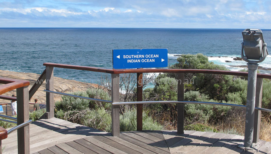
Cape Leeuwin is the most south-westerly point of Australia, and according to our guide one of the world’s most notorious Capes along with Cape of Good Hope and Cape Horn. The Cape is located on the extreme south-west point of Western Australia, where the Indian and Southern Oceans meet.


The lighthouse, which is the tallest mainland lighthouse in Australia, guards one of the busiest sea traffic routes on Australia’s coast.  The shallow rocks stretching 7 kilometres out from the Cape, diverging currents and massive swells claimed 22 ships before the lighthouse was built, and only one since then. Winds can reach 100-160 kilometres on the Cape. 
The position of the light is latitude 340 22’ south, longitude 1150 08’ east.

Here is a little video I took to show you - 


The Cape Leeuwin lighthouse was officially opened by the then Premier of Western Australia, Sir John Forrest, on 10 December 1896. 

The lighthouse was constructed of hand-carved local tamala limestone quarried about 1.2 kilometres away at Quarry Bay, and built on a foundation of 22 feet (6.71 metres).  The walls are 7 feet thick at the base, and a spiral staircase takes you up to the light and the viewing platform. The elevation of the light is 39 metres above the ground and 56 metres above Mean Tide level. 


 Until 1982 the lens of the light was rotated by a counter weight driving a clockwork mechanism, and the beacon was a pressure kerosene mantle type. Think of the lighthouse keepers who had to carry cans of kerosene up the narrow staircase of lighthouse at least four times every day! In 1982 it was converted to hydraulics and electricity. The light was automated in 1992 and has a range of 25 nautical miles. 


 Three lighthouse keepers and their families lived at the Cape and maintained the lighthouse. They only had one day off, Sunday, every two weeks, and if they went away from the lighthouse, had to be back before dark to light the light. Supplies were delivered by ship. 
  
The lighthouse precinct is heritage listed and includes interpretive signage, boardwalks, decking and telescopes. You can go on a guided walk of the Lighthouse, but be warned there are 186 steps to negotiate to get to the top! Or you may choose to take a self-guided audio tour of the precinct which shares information about the history of the lighthouse, its keepers and the area, but this doesn’t include entering the lighthouse. 


  The other lighthouse you can visit in the Capes region is the Cape Naturalist Lighthouse at the northern point of the Capes. The Cape Leeuwin and Cape Naturalist lighthouses mark the start and finish of the 135 kilometre Cape to Cape walking track.

The Cape Leeuwin lighthouse is also a great place to spot Humpback and Southern Right whales May to September as well as fur seals and many varieties of sea birds.

Tours of the Cape Leeuwin Lighthouse operate every half hour from 9.00-4.30pm daily, except Christmas Day.

While you are at the Cape make sure you visit the nearby waterwheel, built in 1895 to supply water during construction of the lighthouse, and later to supply water to the lighthouse keepers’ cottages. The waterwheel was built to power a hydraulic ram to pump water from a nearby natural spring. Today the wheel is encrusted with calcified lime and no longer turns, but it is a reminder of the past.

Also at the Cape is a memorial to 10 sailors aboard the HMAS NIzzan who lost their lives in 1945 when a rogue wave hit the ship. And a memorial to commemorate the contribution of "N" class destroyers in WW2 and those who served in them.

More information on the Cape’s lighthouses and the Cape to Cape Track please click here - Lighthouses - Margaret River Attractions

For information on the Cape Leeuwin Lighthouse heritage value please click here – State Heritage WA

Before we go, one last look at the Cape Leeuwin Lighthouse. I took this photo several years ago when I was taking photos with slide film for a magazine. Yes I have played around with it a bit in digital post processing, but this is wild weather on the Cape. 

Thank you so much for stopping by. I hope you have enjoyed this look at the Cape Leeuwin Lighthouse.  I wish they would open up their cottages for accommodation. I would love to stay there. Have you ever stayed overnight at a lighthouse? Perhaps you would like to tell us about it in your comments. 

I value your comments and look forward to hearing from you. I will try to visit your blogs in return. Have a wonderful week.  

You might also like - 

I am linking up to the link-ups below. Please click on the links to see fabulous contributions from around the world - virtual touring at its best!
Life in Reflection

Hello there! I love reading your comments. If you scroll down to the bottom you can comment too! I would love to hear from you.

If you are a blogger you can also link your blog to Wednesday Around the World at Communal Global.