Welcome to Life Images by Jill

Welcome to Life Images by Jill.........Stepping into the light and bringing together the images and stories of our world. I am a photographer, writer and multi-media artist.
Focussing mainly on Western Australia and Australia, I am seeking to preserve images and memories of the beautiful world in which we live and the people in it.

Welcome!

Welcome!
PLEASE CLICK ON THE IMAGE TO GO TO MY RED BUBBLE STORE.
Showing posts with label everlastings. Show all posts

Monday, 7 October 2024

Midwest wildflower trundle -Part 1 - Perenjori & Camel Soak, Western Australia

 Hi all, I hope all is going well with you and yours. It is now a few weeks since we returned from our Midwest-Gold fields-Wheatbelt trundle which I promised on 23 September to share with you. Where has time gone? Life has been busy. 

Today I am sharing with you the first part of that trip.  But first a map to help you orientate - starting in Bunbury in the south west, north to Perenjori, Mullewa, Wooleen Station, then east to Sandstone, Leonora, Niagra Dam, back west and south to Karalee Rock, Elachbutting Rock, Bruce Rock and back home - 19 days - a distance of 3,588 kilometres. 

Warning - standby for a wildflower overload! But I am not a botanist, so please forgive me any errors in my identification. You can learn more about exploring Western Australia's wildflower trails here - Wildflower Country.com


We left home around 6.45am on the 1st September, with a few stops along the way up through the western wheatbelt, including Coorow (where there is a nice park to stop for lunch and an interesting history/machinery display), 


and Carnamah to see one of Monsignor John Hawe's churches - the Church of St Andrew built in 1930 - one of many churches he designed and built in the region - but that's another story. You can learn more about Monsignor Hawes life and the more than 15 churches he built  - here - Monsignor Hawes.com

We arrived in Perenjori at 1.44 pm and booked into the caravan park, which is very popular with tourists during the wildflower season - we had booked ahead.  Located just a short stroll from town, the caravan park is an ideal place to base yourself while you explore the area. There are powered and unpowered sites, and cabins. 

The name Perenjori is derived from the Aboriginal word “Perangery”, meaning water hole. Sir John Forrest conducted explorations in 1869, and surveyed the area in 1896. Gold was discovered in 1894. When the railway line was officially opened in 1915, the town’s estimated population was 100. Perenjori was officially announced as a town on February 16th 1916. Today Perenjori is one of the largest agricultural Shires in WA, with a combination of farming, pastoral and mining leases.

from Visit Perenjori website

We had enough time in the afternoon to go out to the gravel pit just north of Perenjori to see the distinctive Wreath Leschenaultia - Lechenaultia macrantha - which were just starting to flower. The turn-off is about 6km north of Perenjori. We had seen them here previously, so we knew where to look. They are a species of flowering plant in the family Goodeniaceae and is endemic to inland areas of south-western Western Australia. Wreath Leschenaultia's are a highlight of wildflower trundles. 


We also saw Upside Down Pea Bush - Leptosema daviesioides - whose flowers pop out at ground level under the bush. 


And the Emu Tree - Hakea francisiana - that has a very woody nut


And swaths of pink and white everlastings flowering by the roadside. They are called everlastings due to there papery petals. The white ones you see here are Pom-pom everlastings - 
Cephalipterum drummondii

On Monday morning we visited the Visitor Centre to pick up information, maps and find out from the very helpful assistant what was flowering where. The Visitor Centre is open August – October (Wildflower Season) weekdays from 10am to 2pm. There is also an interesting museum in the same building. 

First we stopped at Monsignor Hawes - St Joseph's Church. The foundation stone was laid in 1937. 


We packed a lunch bag for a wildflower day trip from Perenjori. Leaving via the Perenjori-Rothsay Road east of Perenjori, then turning onto Wanarra Road, our first stop was Orchid Ridge, 33km from Perenjori. This is a rocky ridge on private land. It is very kind of the farm owner to allow visitors onto his land, so please be respectful, don't leave rubbish, and leave gates as you find them. There are walk tracks around the rocky ridge. 

Different orchids flower at different times, and sun orchids open with the sun. We saw blue Granite Sun Orchids - Thelymitra petrophila, white spider orchids, snail orchids, and the Dainty (Shy) Blue Orchid - Cyanicula amplexans


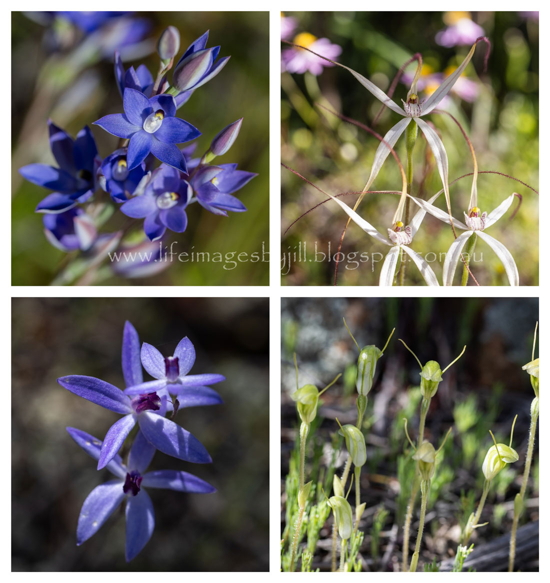
and a new one to us - a hybrid of the Lemon-scented Sun Orchid - Thelymitra antennifera and the Granite Sun Orchid - Thelymitra petroophila - gorgeous! It was under shade so only just opening with the sun. 

We also saw the lovely purply-blue Graceful Honey Myrtle - Melaleuca radula - also new to us. 


And some more Wreath Leschenaultia 500 metres from the farm gate


From here we turned north along the Rabbit Proof Fence Road past Mongers Lake to Camel Soak. This part of the road is sand and gravel but was in a good condition when we travelled. You can't see much of the lake from the Mongers Lake lookout but you can see some of the rabbit proof fence just across the road.


 Below are fringe lilies and the bottle-brush grevillea - Grevillea paradoxa


We arrived at Camel Soak (approx 39 kms east of Perenjori) at around 11.45am. This is a great place to picnic, free-camp or just wander over the granite rock. We have camped here before. There are picnic shelters, BBQ facilities, and toilets and plenty of places to set up. No potable water. The track in can be soft and rutted when wet. The tracks are winding, so be careful of your vehicle width and overhanging branches if you are towing a caravan. 

The Camel Soak granite catchment (also known as the Rock Pool) was sunk as a watering point for men and their camel teams working on the No 2 Rabbit Proof Fence in 1903-1905. During rain the water catchment and gnamma holes on the rock fill with water.

The 1166 km long Number 2 Rabbit Proof Fence, and the 1837 km Number One Fence, stretching from Cape Keraudren on the North West coast to Starvation Harbour on the South coast, were built in an attempt to stop rabbits invading Western Australia’s agricultural regions, but did not however stop the invasion. 

During spring the area around Camel Soak is ablaze with wildflowers - particularly everlastings trailing through the bushland like a carpet. Exploring around the base of the rock and in the little rock gardens where soil has collected, you will find wild orchids. 

Below here you can see the tiny Little Laughing Leek orchid Prasophyllum gracile, the Lemon scented sun orchid - Thelymitra antennifera, and one of the donkey orchid family. 
I love the little faces of the Lemon scented sun orchid, and can you see the ears on the donkey orchids? The Little Laughing Leek orchids are tiny - between 60-200mm tall, very slender and blend into their environment. You need to look carefully in the little rock gardens. 


And a curious plant which I haven't been able to get an identification for yet. Perhaps one of the Samphire species. 


This is one of the Cassia family


And white pom-pom and pink everlastings

 
Yellow everlastings


After lunch at Camel Soak we drove further east along the Perenjori-Warrieddar Copper Mine Road to John Forrest Lookout. The Lookout is located in the Damperwah Hills which Sir John Forrest (explorer and later WA’s first Premier) discovered and named during his failed search in 1869 for the missing German explorer Ludwig Leichhardt. In 1897 Forrest used the hill-top as a survey point during his expedition to Cue and Day Dawn. 

There is a 750 metre walk trail to the top - I am sure it is a lot steeper than the last time we visited! We have also camped here previously. Here is a view from the top. You can also visit the old Rothsay Townsite and Cemetery, but we didn't this trip. 


We'd had a big day, so we treated ourselves to a meal at the pub and visited the War Memorial across the road. Back at camp we watched the Bronze medal wheelchair rugby Paralympics game between Australia and Great Britain on the caravan park's big TV screen. Australia won by 2 points! Yay! Exciting game to watch. 


I hope you have enjoyed Part 1 of our 3 week trundle. I will be back soon with the next instalment. Do you like hunting for wild orchids? Perhaps you would like to tell us about it in your comments. 

You might also like:
Camp among the wildflowers - Camel Soak and John Forrest lookout - 2011

For more information about Perenjori - Visit Perenjori.com.au
Perenjori caravan park - Perenjori caravan park
For more on wildflower trails - Wildflower Country

Thank you so much for stopping by. I value your comments and look forward to hearing from you. I will try to visit your blogs in return. Have a wonderful week. 
I am linking up to the link-ups below. Please click on the links to see fabulous contributions from around the world - virtual touring at its best!
   

Monday, 1 October 2018

Cue - Queen of the Murchison - Western Australia

A couple of weeks ago I brought you the introduction to a series about a recent camping trip we did through Western Australia's inland Murchison and goldfields regions. You can click here to have a read if you missed it: Wildflower hunting and taking time out

Today I bring you part 2.  From Perth to Cue.

Heading up the Great Northern Highway from Perth we camped our first night on the road at Jibberding Nature Reserve 23 kilometres north of Wubin, just north of the rabbit proof fence. 

Jibberding Nature Reserve

This camp was an easy day’s drive from Perth, and after having lunch in the historical monastic town of New Norcia (which deserves a longer visit), we arrived at Jibberding in time for a late afternoon tea. Before reaching the camp site we visited the Wubin Visitor Centre, located in the old railway station adjacent to the Wheatbin Museum, to pick up the latest information on what was flowering where. This is always a must when you are on a wildflower drive, as flowering can change from year to year.  Or you could stop prior to Wubin at the Dalwallinu Discovery Centre. 

New Norcia
Jibberding Nature Reserve is an attractive free camping spot as it is well off the highway amongst trees, and we were not bothered by passing traffic after around 9pm in the evening. The compacted sand-gravel area is good for caravans, camper trailers and tents, but as with many free camping areas, there are no facilities. This was the first time we had camped overnight at Jibberding, but we knew it well as a favoured stopping spot on our way north. 


After setting up our camp we took a walk around the area to see the wildflowers which included white paper lillies, yellow and pink everlastings, velleias, and white daisies, as well as flowering shrubs. 


Below you can see our campsite, part of the Number 2 rabbit proof fence, yellow, white and pink everlastings. 
 Now known as the State Barrier Fence, the 1166 km long Number 2 Fence, and the 1837 km Number 1 Fence, stretches from Cape Keraudren on the North West coast to Starvation Harbour on the South coast. Completed in 1907 the fence was constructed in a failed attempt to keep rabbits and other agricultural pests out of Western Australia’s pastoral region.  People passing through this area until the 1950s had to stop to open and shut the gate in the fence.

Rabbit Proof Fence - in somewhat disrepair
 Our way to Cue we took a short detour down Goodlands Road as we had seen the amazing Wreath Leschenaulta - Lechenaultia macrantha - here before, although we had been told there wasn't much of a display this year. We were lucky to find a few plants.  This unique plant loves graded gravel road verges and it is most sort after by tourists on a wildflower drive. 
Wreath Leschenaultia
From here through to Paynes Find we saw lots of everlastings on the side of the road. These are paper lilys - Laxmannia grandiflora-


Arriving in Cue around mid-afternoon the next day we booked into the Cue Tourist Park which is located a convenient stroll into town.  We hadn’t stayed in Cue before, though we had passed through many times on our way north, so I was looking forward to exploring properly. 

Located 650 kilometres north-east of Perth, Cue was once a wealthy gold mining town at the centre of the Murchison goldfields and known as the “Queen of the Murchison”. At its peak Cue had a population of around 10,000. The is still mining in the area, although Cue’s population is now only around 280.

A very helpful assistant at the Cue Community and Visitor Centre, located in the magnificent Government Buildings, helped us with maps and information about the area, so that we could set out to explore the next day.  These buildings were built from locally quarried stone and originally housed the Warden's Court, Post Office and Police Station. Completed in 1896, additions were made in 1897 and 1898.


 Although the town is named after prospector Tom Cue, gold was found in Cue on 1st January 1892 by Mick Fitzgerald and his aboriginal companion, Governor. Within days the alluvial patch became the scene of a huge gold rush, coinciding with WA’s gold mining boom. The town grew rapidly and by 1894 thirteen companies operated gold batteries.
Cue's rich history has been preserved in its magnificent buildings, many constructed from locally quarried stone at the turn of the century.  

A 2.7 kilometre Town Heritage Walk Trail takes in 13 sites of historical interest, starting with the Gaol located at the caravan park, and including the impressive Government Buildings, Gentleman’s Club, Masonic Lodge, Railway Station and the bandstand Rotunda. The cultural and architectural significance of Cue’s main street, Austin Street, precinct has been recognised by the National Trust of Australia (WA). 

Clockwise below you can see - The Gentleman's Club, Rotunda with the old Bank of New South Wales behind,  detail of the Masonic Lodge, detail of balustrading, the Cue Hotel, and the Masonic Lodge. (Built in 1899 of timer and corrugated iron with a pressed tin interior - corrugated iron was used extensively throughout the goldfields at it was easily transported by camels).

 A 13 kilometre drive trail includes the Great Fingal Mine Office at Day Dawn mine, built by Italian stonemasons in 1902 (unfortunately you can now only view through a fence because of mining restrictions), and the ruins of old hospital. A drive up to the Cue lookout gives you good views over the town.  Below you can see the Great Fingal Mine Office. 


 Further afield, a must see is Walga Rock 48 kilometres west of Cue on Austin Downs Station. Known to local Aborigines as Wolgarna Rock or Walgahna Rock, it is the second largest monolith in Australia, after Uluru in the Northern Territory. Walga Rock is five kilometres in diameter, 1.5 kilometres long and 478 metres high.

Walga Rock has the largest gallery of Aboriginal rock paintings in the Murchison.  The 60 metre long gallery of over 988 motifs is located under a sheltered overhang on the western side, a short distance from the carpark.  Dated with radio-carbon tests by archaeologists to be about 10,000 years old.


The most unusual painting is of a sailing ship. 2 metres high and 325 kilometres from the coast, with details of masts, rigging and portholes and what appears to be Arabic- style writing underneath the painting. Dating has proved difficult and there is speculation and many theories about its origin. Could it have been drawn by an aboriginal who had been to the coast? One theory is that it was made by a Dutch sailor shipwrecked on the coast and looked after by aborigines. Another theory suggests it was made by an Afghan camel guide.  Experts are still puzzled and perhaps its real origins will never be known, but it is certainly fascinating to ponder over.


Camping is not permitted at Walga Rock, but it is a great place for a picnic, and you can drive along the track around the base of the rock. We stopped numerous times to view the rock and wildflowers.  Please remember this is a site of deep cultural and spiritual significance to the Aboriginals and be respectful when you visit.  


Please shut the gates and look out for cattle and wildlife on the roadside when driving through the station.  Pet dogs are not encouraged due to poison bating for wild dogs and foxes. 

Below you can see one of the Cassia (Senna) varieties. A shrub or small tree they are an attractive splash of colour.
One of the Cassia varieties
On your way to Walga Rock I recommend visiting the abandoned Big Bell town site, 30 kilometres from Cue. Gazetted in 1936, the town rapidly declined after the mine closed in 1955. There is a site map and interpretive signage to help you explore what remains of the town, including the Big Bell Hotel which evidently once boasted the longest bar in Australia.
I hope you have enjoyed this look at Cue. Thank you so much for stopping by. I value your comments and look forward to hearing from you. I will try to visit your blogs in return. Have a wonderful week.  

You might also like:
 Murchison River camping at Wooleen Station
Kennedy Ranges, Pilbara, Western Australia
Everlasting Magic, mid-west, Western Australia

I am linking up to the link-ups below. Please click on the links to see fabulous contributions from around the world - virtual touring at its best!
Life in Reflection

Hello there! I love reading your comments. If you scroll down to the bottom you can comment too! I would love to hear from you.


Monday, 21 July 2014

Everlasting magic - midwest Western Australia

We have been away for the last 2 weeks travelling and camping in our Pilbara and Mid-West region through Karijini National Park, Mt Augustus, Kennedy Ranges and Coalseam. The wildflowers particularly on our way south between Murchison and Mullewa in the Mid-West region were starting to come into bloom. The everlasting wildflowers were opening their white, pink and yellow faces, and spreading across the red dust like a carpet through the trees as far as you could see. It is hard to show you how magnificent there were.


 Those of you who have stopped by my blog from time to time will have seen my white everlastings images that have gone through several transformations the last couple of years.  Everlastings have papery petals and if you pick them and dry them upside down they can last for years.


 To keep reading and see more pics, please click on "read more" .....