

Last week we managed to put aside a few days to go away in our caravan. Travelling only a couple of hours south from our home put us in the heart of the beautiful Cape to Cape region of Western Australia’s beautiful south west. This is the area between Cape Naturalist and Cape Leeuwin, arguably one the most beautiful part of Western Australia abounding with beaches, forests, caves, wineries, restaurants, galleries, bush walks and escapes, and much more.
By lunchtime we had booked into the Hamelin Bay caravan park situated in the Leeuwin Naturalist National Park, and within a short walking distance – only about 500 metres, to the beach.
But more about Hamelin Bay another day.

On one of our days we re-visited the Cape Leeuwin Lighthouse. Situated just south of Augusta, Cape Leeuwin was named by Matthew Flinders on 7 December, 1801, during his circumnavigation of Terra Australis (Australia), taking the name from the Dutch navigators, Leeuwin’s Land, when the ship the Leeuwin (The Lioness) rounded the cape in March 1622.
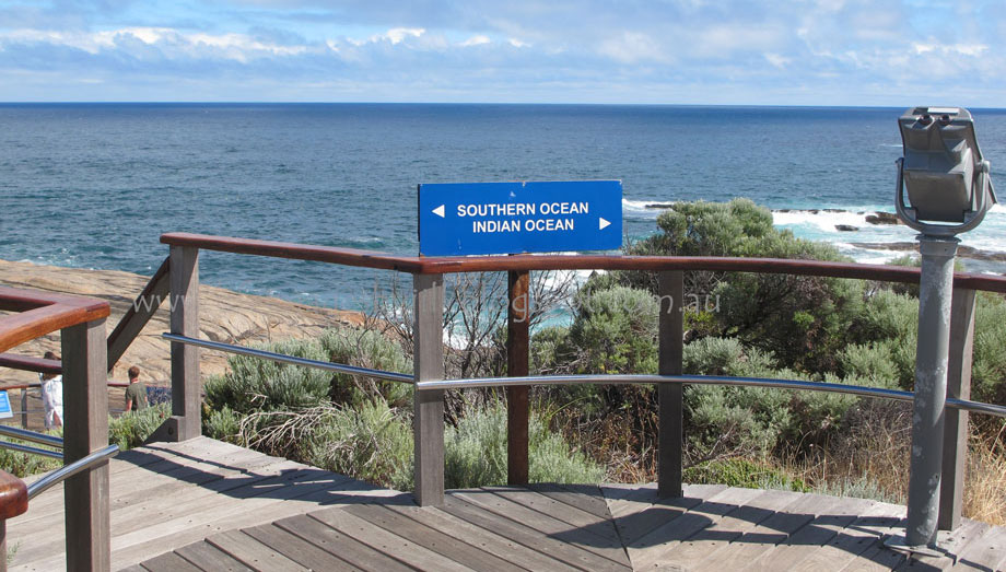
Cape Leeuwin is the most south-westerly point of Australia, and according to our guide one of the world’s most notorious Capes along with Cape of Good Hope and Cape Horn. The Cape is located on the extreme south-west point of Western Australia, where
the Indian and Southern Oceans meet.


The lighthouse, which is the tallest mainland lighthouse in Australia, guards one of the busiest sea traffic routes on Australia’s coast. The shallow rocks stretching 7 kilometres out from the Cape, diverging currents and massive swells claimed 22 ships before the lighthouse was built, and only one since then. Winds can reach 100-160 kilometres on the Cape.
The position of the light is latitude 340 22’ south, longitude 1150 08’ east.
Here is a little video I took to show you -
The position of the light is latitude 340 22’ south, longitude 1150 08’ east.
Here is a little video I took to show you -
The Cape Leeuwin lighthouse was officially opened by the then Premier of Western Australia, Sir John Forrest, on 10 December 1896.


Until 1982 the lens of the light was rotated by a counter weight driving a clockwork mechanism, and the beacon was a pressure kerosene mantle type. Think of the lighthouse keepers who had to carry cans of kerosene up the narrow staircase of lighthouse at least four times every day! In 1982 it was converted to hydraulics and electricity. The light was automated in 1992 and has a range of 25 nautical miles.

Three lighthouse keepers and their families lived at the Cape and maintained the lighthouse. They only had one day off, Sunday, every two weeks, and if they went away from the lighthouse, had to be back before dark to light the light. Supplies were delivered by ship.
The lighthouse precinct is heritage listed and includes interpretive signage, boardwalks, decking and telescopes. You can go on a guided walk of the Lighthouse, but be warned there are 186 steps to negotiate to get to the top! Or you may choose to take a self-guided audio tour of the precinct which shares information about the history of the lighthouse, its keepers and the area, but this doesn’t include entering the lighthouse.


The other lighthouse you can visit in the Capes region is the Cape Naturalist Lighthouse at the northern point of the Capes. The Cape Leeuwin and Cape Naturalist lighthouses mark the start and finish of the 135 kilometre Cape to Cape walking track.
The Cape Leeuwin lighthouse is also a great place to spot Humpback and Southern Right whales May to September as well as fur seals and many varieties of sea birds.
Tours of the Cape Leeuwin Lighthouse operate every half hour from 9.00-4.30pm daily, except Christmas Day.
While you are at the Cape make sure you visit the nearby waterwheel, built in 1895 to supply water during construction of the lighthouse, and later to supply water to the lighthouse keepers’ cottages. The waterwheel was built to power a hydraulic ram to pump water from a nearby natural spring. Today the wheel is encrusted with calcified lime and no longer turns, but it is a reminder of the past.

Also at the Cape is a memorial to 10 sailors aboard the HMAS NIzzan who lost their lives in 1945 when a rogue wave hit the ship. And a memorial to commemorate the contribution of "N" class destroyers in WW2 and those who served in them.
More information on the Cape’s lighthouses and the Cape to Cape Track please click here - Lighthouses - Margaret River Attractions
For information on the Cape Leeuwin Lighthouse heritage value please click here – State Heritage WA
Before we go, one last look at the Cape Leeuwin Lighthouse. I took this photo several years ago when I was taking photos with slide film for a magazine. Yes I have played around with it a bit in digital post processing, but this is wild weather on the Cape.

Thank you so much for stopping by. I hope you have enjoyed this look at the Cape Leeuwin Lighthouse. I wish they would open up their cottages for accommodation. I would love to stay there. Have you ever stayed overnight at a lighthouse? Perhaps you would like to tell us about it in your comments.
I value your comments and look forward to hearing from you. I will try to visit your blogs in return. Have a wonderful week.
You might also like -
I am linking up to the link-ups below. Please click on the links to see fabulous contributions from around the world - virtual touring at its best!

Image-in-ing
Wednesday Around the World at Communal Global
Travel Photo Thursday
Wednesday Around the World at Communal Global
Travel Photo Thursday
Life in Reflection
Hello there! I love reading your comments. If you scroll down to the bottom you can comment too! I would love to hear from you.
If you are a blogger you can also link your blog to Wednesday Around the World at Communal Global.
Hello there! I love reading your comments. If you scroll down to the bottom you can comment too! I would love to hear from you.
If you are a blogger you can also link your blog to Wednesday Around the World at Communal Global.
