In Bunbury where I live we are blessed with water on three sides - the Indian Ocean, Koombana Bay and the Leschenault Inlet - in fact Bunbury is known as the City of Three Waters.
Today we took advantage of the beautiful sunny day to take a walk around the Leschenault Inlet which is virtually right in the centre of the city. This is a view across the Inlet to the city. Can you guess what the building in the centre of the picture is known as? The milk carton! I am sure you can see why. It is the tallest building in our city. My husband says it is a good landmark when you are out in the ocean in a boat.
Here you can see the Bunbury Rowing Club and Waterfront Cafe, boats at the Bunbury Yacht Club, and the view of the Inlet looking east.
An easy walk trail, suitable for walkers, bikes, wheelchairs, and prams, is an approximately 5 kilometres circuit around the Leschenault Inlet. We weren't the only ones out enjoying the sun.
A major feature of the Leschenault Inlet are the White Mangroves (Avicennia marina var. marina). Normally associated with the north west, these mangroves are the most southern occurrence in Western Australia and a remainder of a time when the south west had a more tropical climate. The nearest white mangroves are 700 kilometres to the north at the Abrolhos Islands.
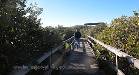
The mangroves are an important conservation area protecting the aquatic and bird life that live here, and also migratory birds that visit from Northern Europe and Asia every year to feed on the mudflats during our summer. A board walk, which was carefully constructed so as to cause minimal damage to the environment, meanders through the mangroves so you can see them up close.
Unfortunately no bird photos, we could hear them but not see them!
You can read about the ecology at the various interpretive signage along the way.
Between the mangroves and the ocean is an extensive area of the Koombana Bay waterfront which is currently being redeveloped. This is as close as I could get to it. It will be interesting to see how it develops.
The path then meanders through a grove of Swamp Sheoaks - Casuarine obesa - which is a salt tolerant variety found near bodies of water.
You then turn onto a new path which skirts along the edge of the water and the main road into the city. From here you can see Anglesea Island - also known as Pig Island. The story goes that an early settler put his pigs on the island to save on fencing. The pigs drowned when they tried to escape by swimming back to the mainland. The island became known as Pig Island.
The waterway here is called "The Blunders" due to the "blunder" with the pigs.
When you reach the end of this new walkway the path turns around the end of the Inlet. Here is the view across the water to the city and the waterfront houses. Can you see the "milk carton" in the distance?
It is interesting to note that the inlet didn't always end here. Originally this was the Preston River which flowed through here down towards the Bunbury townsite, and then into Koombana Bay. However land was reclaimed and the river diverted northward into the Leschenault Estuary and a new opening to the ocean created, called The Cut, as part of the Inner Harbour building project in the 1970s.
You can see the changes in these two old maps from 1850 and 1980 showing Koombana Bay, the Preston River, Leschenault Inlet & Estuary, and the Inner Harbour - (Barnes, P. 2001, Marlston Hill and all that).
The name Leschenault honours botanist Jean Baptiste Leschenault de la Tour, who was part of Nicolas Baudin's 1800–1804 voyage which visited the coast and explored the estuary and nearby rivers. The Baudin espedition was a French expedition to map the coast of New Holland (now Australia). More info here - Australian Dictionery of Biography
The bees were having a high time in this tree of beautiful red gum flowers we saw along the path.
and back into the city - now you can see the Bunbury Tower - the "milk carton" up close.
And a place to sit and look out over Koombana Bay towards the Outer Harbour.
I'll have to bring you back here when they are finished with the "redevelopment" of the Koombana Bay foreshore.
Some interesting information on the Leschenault Inlet can be found in these reports:
A Sense of Home: A Cultural Geography of the Leschenault Estuary District.
A Report of an Aboriginal Heritage Sruvey of the Preston River Realignment and the Bunbury Port Inner Harbour Expansion Plan
 And these sites:
Mangrove Watch Australia
Thank you so much for stopping by. I hope you have enjoyed this walk today with me around the Leschenault Inlet. I certainly learned some new things on my walk.
I value your comments and look forward to hearing from you. I will try to visit your blogs in return. Have a wonderful week.
I am linking up to the link-ups below. Please click on the links to see fabulous contributions from around the world - virtual touring at its best!
Mosaic Monday
Our World Tuesday
Pictorial Tuesday
Through My Lens
Image-in-ing
Wednesday Around the World at Communal Global
Travel Photo Thursday
The Lovin' Life Team over at Lifestyle Fifty
Sky Watch Friday
Life in Reflection


